

Historical and Contemporary Comparison Maps
Files
Download Full Text (7.3 MB)
Subject
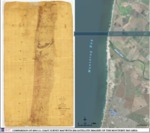
1854 map and 2016 satellite map of the coast of Monterey Bay from Salinas River southward.
Description
A (draft) comparison map of an 1854 U.S. Coast Survey Map of the coast of Monterey Bay from Salinas River southward with a 2016 satellite imagery of the same region reflecting changes in land use over the preceding 162 years.
Source
Stetson Engineers Inc.
Format
Language
English
Disciplines
Arts and Humanities | Business | Education | Law | Life Sciences | Social and Behavioral Sciences
Original Format
Paper and Digital
Document Type
Map
Recommended Citation
"Comparison of 1854 U.S. Coast Survey Map with 2016 Satellite Imagery of the Monterey Bay Area" (2018). Historical and Contemporary Comparison Maps. 4.
https://digitalcommons.csumb.edu/hornbeck_cgb_12/4
Included in
Arts and Humanities Commons, Business Commons, Education Commons, Law Commons, Life Sciences Commons, Social and Behavioral Sciences Commons