
2014 – Historic Seawater Intrusion Map, Pressure 180-Foot Aquifer for the Years 1944-2013
Description
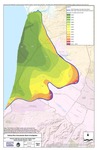
The Fig. 5-1 map included in the 2016 State of the Salinas River Groundwater Basin summarizes the rate of seawater intrusion into 180-foot aquifer located in the northern Salinas Valley, Monterey County, from 1944 through 2013. The rates were estimated by Monterey County Water Resources Agency.
This paper has been withdrawn.
