
Files
Download
Download Full Text (2.9 MB)
Subject
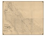
1898 map of Monterey County, California, detailing ranchos, township and range.
Description
Map prepared in 1898 by Lou G. Hare, County Surveyor, from public records, coast and geodetic surveys, government surveys of public lands and private surveys. Details include trails, roads, railroads, irrigation canals and county boundary.
Source
Library of Congress
Format
JPG File
Language
English
Disciplines
Arts and Humanities | Education | Law | Social and Behavioral Sciences
Original Format
Paper
Document Type
Map
Recommended Citation
"1898 - Official Map of Monterey County, California" (2016). Groundwater Basin Maps. 3.
https://digitalcommons.csumb.edu/hornbeck_cgb_4/3
