
Files
Download
Download Full Text (17.7 MB)
Subject
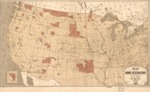
1883 map depicting the location of Indian reservations within the United States.
Description
An 1883 map compiled under the direction of Hiram Price, Commissioner of Indian Affairs, showing the Indian reservations within the limits of the United States. Insert of Indian Territory in Northeastern Oklahoma.
Source
Library of Congress
Format
JPG2 File
Language
English
Disciplines
Arts and Humanities | Education | Social and Behavioral Sciences
Original Format
Paper
Document Type
Map
Recommended Citation
"1883 - Map showing Indian reservations with the limits of the United States" (2017). Maps. 6.
https://digitalcommons.csumb.edu/hornbeck_ind_2/6
