
Files
Download Full Text (6.3 MB)
Subject
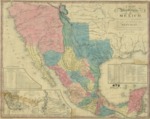
1832 map of the United States of Mexico by H. S. Tanner, (2nd edition, 1846, of 1832 map).
Description
This 1846 second edition map depicts the United States of Mexico in 1832; organized and defined by the Acts of the Congress of the Republic; constructed from printed and manuscript documents by H. S. Tanner. Insert table on lower right shows statistical data for the states and territories: Area in Sq. Miles, Miles Square, Population, number of inhabitants to square mile, Capital and it's position Latitude and Longitude) along with population, produce, and terrain. Table of Distances insert on lower left.
Source
Bureau of Indian Affairs
Format
PDF File
Language
English
Disciplines
Arts and Humanities | Education | Law | Social and Behavioral Sciences
Original Format
Paper
Document Type
Article
Recommended Citation
"1832 Map of United States of Mexico, Second Edition 1846" (2016). Pre-1846 Maps. 1.
https://digitalcommons.csumb.edu/hornbeck_mex_1/1
Included in
Arts and Humanities Commons, Education Commons, Law Commons, Social and Behavioral Sciences Commons
