
Files
Download Full Text (2.1 MB)
Subject
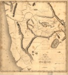
1837 map of the Territory West of the Rocky Mountains published in Washington Irving's 1937 book, The Adventures of Captain Bonneville, that was based on the explorations of Capt. Bonneville.
Description
The 1837 map extends from Monterey, California to Cape Flattery and inland to Flathead Lake in today's Montana. The Great Salt Lake is named Lake Bonneville. It locates and names the Salmon, Boise, Malade, Snake, Columbia and Flat Head Rivers. Several dead-end rivers and lakes are shown in the Great Basin area including Lost River, Ashley's Lake, Battle Lake, and the Mary or Ogden's River. The map also depcits the territories of the Shoshoco, Eutaw, Too-el-Iican, Skynses, Flat Head, Pends Oreilles, Wallawallah and Bannack Indians. The three buttes located in the Lava Plains of Idaho were off navigational importance to the western immigrants.
Source
Library of Congress
Format
JPG File
Language
English
Disciplines
Arts and Humanities | Education | Social and Behavioral Sciences
Original Format
Paper
Document Type
Map
Recommended Citation
"1837 - Map of the territory west of the Rocky Mountains" (2017). Pre-1846 Maps. 5.
https://digitalcommons.csumb.edu/hornbeck_mex_1/5
