
Title
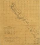
1847 - Map of Upper & Lower California showing the military stations and distribution of troops.
Files
Download Full Text (3.7 MB)
Subject
This hand-drawn map of 1847 shows the locations in Alta California where U.S. forces were stationed. It shows the coastline of California, mountains, towns and missions, and El Camino Real (The Royal Road), the Spanish-built road that ran from San Diego in the south to Sonoma, just north of San Francisco Bay, connecting the 21 Spanish-built missions.
Description
This 1847 map depicts the locations in Upper California where U.S. forces were stationed. The notation on the lower left-hand side gives the distances between sites and the numbers of men deployed. Longitude and latitude are marked but there is no exact scale. The map shows the extent of U.S. control, later to be formalized in the Treaty of Guadalupe Hidalgo of 1848, which transferred to the United States a vast swath of land that included not only California but the future states of Nevada, Utah, Arizona, and parts of Colorado and Wyoming. It shows the coastline of California, coastal features, streams, mountains, towns and missions. The map depicts the El Camino Real (The Royal Road), the Spanish-built road that ran from San Diego in the south to Sonoma, just north of San Francisco Bay, connecting the 21 Spanish-built missions. Marked on the map south of Sacramento is “Suter’s,” a reference to Sutter’s Mill, where the discovery that set off the California Gold Rush was made in early 1848.
Source
Library of Congress
Format
JPG File
Language
English
Original Format
Paper
Document Type
Map
Recommended Citation
"1847 - Map of Upper & Lower California showing the military stations and distribution of troops." (2017). Pre-1846 Maps. 8.
https://digitalcommons.csumb.edu/hornbeck_mex_1/8
