
Title
1784-1846 - Spanish Land Concessions and Mexican Land Grants in Alta California, David Hornbeck
Files
Download Full Text (2.0 MB)
Subject
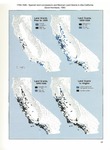
Maps showing the distribution of Spanish land concessions and Mexican land grants made in Alta California from 1784 through 1846.
Description
Maps reflecting the distribution of land concessions and land grants made in Alta California during the Spanish and Mexican eras (1784 through 1846). Maps are divided into four categories: land grants issued prior to 1829; land grants issued between 1830 and 1839; land grants issued between 18840 and 1846; and land grants issued to Anglos.
Source
California Patterns: A Geographical and Historical Atlas, David Hornbeck, 1983
Format
PDF File
Language
English
Disciplines
Arts and Humanities | Education | Law | Social and Behavioral Sciences
Original Format
Paper
Document Type
Map
Recommended Citation
"1784-1846 - Spanish Land Concessions and Mexican Land Grants in Alta California, David Hornbeck" (2017). Pre-1846 Maps. 9.
https://digitalcommons.csumb.edu/hornbeck_mex_1/9
Included in
Arts and Humanities Commons, Education Commons, Law Commons, Social and Behavioral Sciences Commons
