
Files
Download Full Text (1.8 MB)
Subject
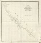
Map published in 1802 based on the exploration of the California coastline from Cabo San Lucas to Cape Mendocino by Sebastian Vizcayno in 1602-1603.
Description
The first comprehensive depiction of the coastline of California, this map was published 1802 in Juan Espinosa y Tello’s atlas entitled, “Atlas para el viage de las goletas Sutil y Mexicana al reconocimiento del estrecho de Juan de Fuca in 1792, publicad en 1802.” In his 1602-1603 expedition along the California coast, Vizcayno made thirty-two plans of harbors and portions of the coast. His plans subsequently were placed in the Madrid archives. Some 200 years later, the officers of the ships, Sutil and Mexicana, discovered the old charts and compiled them into a single map. Vizcayno assigned names to many of the well-known features along the California coastline including San Diego Bay, Santa Barbara Channel Islands, Point Conception, Santa Lucia Mountains, Point Lobos, Carmel River and Monterey Bay. For further information regarding the 1602-1603 voyage of Sebastián Vizcaíno, see also: http://escholarship.org/uc/item/38295559.
Source
Cartographic and Study Archive, Geographic Center of the Army, Madrid, Spain
Format
PDF File
Language
Spanish
Disciplines
Arts and Humanities | Education | Social and Behavioral Sciences
Original Format
Paper
Document Type
Map
Recommended Citation
"1602 - Carta de los reconocimientos hechos en 1602 por el Capitan Sebastian Vizcayno -formada por los Planos que hizo el mismo durante su comisión - Cardano lo grabó" (2017). Pre-1824 Maps. 22.
https://digitalcommons.csumb.edu/hornbeck_spa_1_a/22
