
Files
Download Full Text (3.4 MB)
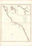
Subject
A map published in 1828 in France depicting a portion of the West Coast from Bodega Bay, California, in the north down to El Rosario and south in Baja, California as surveyed in 1793 .
Description
Map published in France in 1828 depicting the West Coast from Bodega Bay, California, to El Rosario, Baja California as described by Captain George Vancouver of the British Royal Navy during his exploration of this region in 1793. The map shows vessels' tracks and depths by soundings. The two inset maps of Port of San Diego and entrance to the Port of San Francisco show relief by hachures; depths by soundings.
Source
Archivo General Militar de Madrid, Spain
Format
PDF File
Language
French
Disciplines
Arts and Humanities | Education | Social and Behavioral Sciences
Original Format
Paper
Document Type
Map
Recommended Citation
"1828 - Cote Nord-Quest de L'Amérique Reconnue par le Cap. Vancouver" (2017). Pre-1824 Maps. 26.
https://digitalcommons.csumb.edu/hornbeck_spa_1_a/26
