
Files
Download Full Text (3.0 MB)
Subject
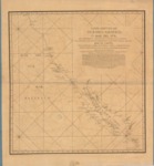
1770 chart of the Pacific Ocean, the entire eastern and western coast of the California peninsula, the Sea of Cortez, and the coasts of North America, from the isthmus that connects this peninsula with the mainland to the River of the Kings (R de los Reyes), and from the Colorado River to the Cape of Corrientes
Description
The chart was drawn by Miguel Constanzó, royal engineer for the Kingdom of New Spain, who accompanied the 1769 expedition led by Captain Gaspar de Portola to establish a settlement at Monterey Bay previously discovered by Sebastián Vizcaino in 1603. The chart depicts the Pacific Ocean, the entire eastern and western coast of the California peninsula, the Sea of Cortez, and the coasts of North America, from the isthmus that connects this peninsula with the mainland to the River of the Kings (R de los Reyes), and from the Colorado River to the Cape of Corrientes.
Source
Archivo General Militar de Madrid, Spain
Format
PDF File
Language
Spanish
Disciplines
Arts and Humanities | Education | Social and Behavioral Sciences
Original Format
Paper
Document Type
Map
Recommended Citation
"1770 - Carta Reducida del Oceano Asiatico, Ó Mar Del Súr, Que Comprehende La Costa Oriental Y Occidental De La Península De La California, Con El Golfo De Su Denominacion Antiguamente Conocido Por La De Mar De Cortés" (2017). Pre-1824 Maps. 27.
https://digitalcommons.csumb.edu/hornbeck_spa_1_a/27
