
Files
Download Full Text (752 KB)
Subject
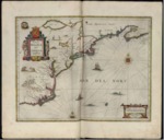
A 1647 map oriented to the North, it depicts the East Coast of North America showing New England, New Amsterdam and Virginia and extending from Nova Scotia (Nova Franciae) south to Cape Lookout (C. of Feare) at the south end of the outer banks of North Carolina.
Description
This second edition map of Johannes Janssonius, Dutch cartographer, is believed to have been derived from the less well circulated map of Johannes de Laet of 1630. The map depicts the East Coast of North America showing New England, New Amsterdam and Virginia extending from Nova Scotia south to Cape Lookout (erroneously identified as C. of Feare) at the south end of the outer banks of what would later be known as North Carolina. It was the second printed map to name Manhattan (Manhattes), New Amesterdam, the North River (Hudson) and South River (Delaware). Emphasis is on the Dutch colonies. Drawing on the cartouche of Johannes Blaeu, another Dutch cartographer, Janssonius added to the second edition engravings of wildlife, along with an Indian village scene.
Source
Archivo Cartografico y de Estudios Geograficos, Madrid, Spain
Format
JPEG
Language
Latin
Disciplines
Arts and Humanities | Education | Social and Behavioral Sciences
Original Format
Paper
Document Type
Map
Recommended Citation
"1647 - Nova Belgica et Anglia Nova" (2017). Pre-1824 Maps. 31.
https://digitalcommons.csumb.edu/hornbeck_spa_1_a/31
