
Files
Download Full Text (480 KB)
Subject
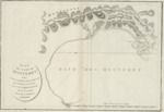
1797 map of the Monterey Bay, California
Description
A first edition 1797 plan of Monterey Bay, California, by Jean Francois Galaup de La Pérouse who arrived in Monterey Bay in September 1786 where he remained for several days surveying the region. The map was included in a detailed accounting of La Pérouse’s explorations in the Pacific Ocean as Plate 34. The report published in 1797 was entitled, Voyage de la Pérouse Around the World, Published in accordance with the Decree of April 22, 1791, and Written by MLA Milet-Mureau, General of Brigade in the Corps of Genius, Director of Fortifications, Ex-Constituent, Member of several Literary Societies of Paris, detailing the explorations of La Pérouse between 1785 and 1788.
Source
Archivo Cartografico y de Estudios Geograficos, Madrid, Spain
Format
JPEG
Language
French
Disciplines
Arts and Humanities | Education | Social and Behavioral Sciences
Original Format
Paper
Document Type
Map
Recommended Citation
"1797 - Plan De La Baie De Monterey, Situee Dans La Calife Septentrionale" (2017). Pre-1824 Maps. 32.
https://digitalcommons.csumb.edu/hornbeck_spa_1_a/32
