
Files
Download Full Text (1021 KB)
Subject
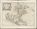
1677 map published by Giovanni G. de Rossi depicting North America, Central America and West Indies with California depicted as an island.
Description
An early map by Giovanni G. de Rossi is thought to have been taken largely from Guglielmo Sansone’s 1669 map with some additions such as Iceland and the British Islands. The map was a part of de Rossi’s atlas of maps entitled Mercurio Geografico. The actual shape that is depicted of Isola di California is believed to have been derived from a 1635 map made by English explorer, Luke Foxe. San Diego, Santa Barbara, Monterey, Point Reyes, Mendocino and other recognizable landmarks are noted on the western portion of the California island. Canada is named in the east. New France is shown as most of the northeast portion of the continent. Also depicted is New England and the Low Countries (the Netherlands) with New Amsterdam (New York City). Significant attention is paid to the West Indies and islands throughout the Gulf of Mexico, as well as to Mexico and other regions throughout Central America.
Source
Archivo Cartografico y de Estudios Geograficos, Madrid, Spain
Format
JPEG
Language
Italian
Disciplines
Arts and Humanities | Education | Social and Behavioral Sciences
Original Format
Paper
Document Type
Map
Recommended Citation
"1677 - L’America settentrionale nuovamente corretta, et accresciuta secondo le relationi più moderne da Guglielmo Sansone" (2017). Pre-1824 Maps. 34.
https://digitalcommons.csumb.edu/hornbeck_spa_1_a/34
