
Files
Download Full Text (240 KB)
Subject
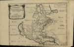
1705 French map depicting North America and polar lands.
Description
A 1705 map by Nicholas de Fer of North America and the polar regions showing Greenland, Iceland. The map also depicts the Hudson Bay, Great Lakes, New England, New Holland, Pennsylvania, New York, Chesapeake Bay, Virginia, Carolinas and Florida. The map shows the Canadian French lands bordering on a westerly extended Florida and abutting New Mexico. The West Indies are depicted as is Mexico with only a small number of communities identified. California is depicted as an island with an indented northern coast and no place names. In the portion of the map that would correspond to the present-day West Coast north of California, there is a note indicating this region as unknown.
Source
Archivo Cartografico y de Estudios Geograficos, Madrid, Spain
Format
JPEG
Language
French
Disciplines
Arts and Humanities | Education | Social and Behavioral Sciences
Original Format
Paper
Document Type
Map
Recommended Citation
"1705 French map depicting North America and polar lands." (2017). Pre-1824 Maps. 35.
https://digitalcommons.csumb.edu/hornbeck_spa_1_a/35
