
Files
Download Full Text (2.4 MB)
Subject
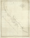
1792 Spanish map depicting the West Coast of America from Acapulco to Cape Perpetua, north of Cape Mendocino.
Description
Published in 1802, the map was included in an atlas entitled, Atlas Para el Viage de las Goletas Sutil y Mexicana el Reconocimiento del Estrecho de Juan de Fuca en 1792. The atlas accompanied an account of the expedition entitled, Relación del viaje hecho por las goletas Sutil y mexicanas en el año de 1792 para reconocer el Estrecho de Fuca; con una introducción en la que se dan noticias de las expediciones previamente ejecutadas por los españoles en busca del paso del noroeste de la América. The map depicts landmarks from Acapulco to Cape Perpetua, north of Cape Mendocino. The expedition was the last made by the Spanish to the Northwest Coast. The two vessels, Sutil and Mexicana, departed Acapulco on March 8, 1792, arrived at the Spanish post at Nootka Sound on the west coast of Vancouver Island on May 12, 1792, in search for the water passage between the Pacific Ocean and Atlantic Ocean. They returned to San Blas on November 25, 1792. The outcome of this expedition was the conclusion that a water passage south of Cook Inlet did not exist.
Source
Archivo Cartografico y de Estudios Geograficos, Madrid, Spain
Format
JPEG
Language
Spanish
Disciplines
Arts and Humanities | Education | Social and Behavioral Sciences
Original Format
Paper
Document Type
Map
Recommended Citation
"1792 – Número 1°, Carta Esferica de los Reconocimientos Hechos en la Costa N.O. de América en 1791 y 92 por las Goletas Sutil y Mexicana" (2017). Pre-1824 Maps. 39.
https://digitalcommons.csumb.edu/hornbeck_spa_1_a/39
