
Files
Download Full Text (3.2 MB)
Subject
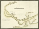
Early map of the San Francisco Bay, California.
Description
Early San Francisco Bay, California, map based on the diary and observations of Franciscan missionary and explorer, Juan Crespí. He made two overland explorations. The first journey was in 1769 with Gaspar de Portolá and Junipero Serra. Crespi accompanied Captain Pedro Fages in 1772 on an exploration of the region to the east of San Francisco Bay. His diaries were first published in English in 1927 (Fray Juan Crespi, Missionary Explorer on the Pacific Coast 1769-1774) and subsequently in 2001 (A Description of Distant Roads: Original Journals of the First Expedition into California, 1769–1770). The 2001 publication contained both the original Spanish and English translation on facing pages. A slightly more detailed version of this map appears in the 1927 publication.
Source
Archivo Cartografico y de Estudios Geograficos, Madrid, Spain
Format
JPEG
Language
Spanish
Disciplines
Arts and Humanities | Education | Social and Behavioral Sciences
Original Format
Paper
Document Type
Map
Recommended Citation
"1772 - Carta del Puerto y Rio de Sn Francisco explorado por tierra en el Mes de Marzo del presente año 1772, formada por el Diario del R.P.Fr. Juan Crespí" (2017). Pre-1824 Maps. 41.
https://digitalcommons.csumb.edu/hornbeck_spa_1_a/41
