
Files
Download Full Text (2.0 MB)
Subject
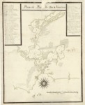
Early map depicting the San Francisco Bay, including the proposed location of the new presidio and mission.
Description
An early detailed map of the San Francisco Bay based on the information acquired by Jose de Cañizares during his exploration of the Bay in 1775 and 1776. Because of the competing interest of England and Russia with Spain for domination of the Pacific Coast, Viceroy Burcareli of New Spain ordered that a fort be established at the Port of San Francisco. Juan Manuel de Ayala, who was in command and master of the ship, San Carlos, had orders to survey the port of San Francisco in conjunction with the land expedition from Sonora under Captain Juan Bautista de Anza who was bringing colonists and supplies for the new outpost. Ayala, brought his ship through the Golden Gate on August 4, 1755. Jose de Cañizares, the first sailing master on the San Carlos, drew an initial chart based upon their 1775 exploration of the Bay. Returning in 1776 as Captain of the San Carolos, Cañzares drew a second chart using a sounding line and compass blended with his personal observations. The chart also shows the proposed location of the new presidio and mission.
Source
Archivo Cartografico y de Estudios Geograficos, Madrid, Spain
Format
JPEG
Language
Spanish
Disciplines
Arts and Humanities | Education | Social and Behavioral Sciences
Original Format
Paper
Document Type
Map
Recommended Citation
"1776 - Plano del Puerto de San Francisco" (2017). Pre-1824 Maps. 43.
https://digitalcommons.csumb.edu/hornbeck_spa_1_a/43
