
Files
Download Full Text (788 KB)
Subject
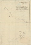
Early California map reflecting the Central California coastline from Ano Nuevo State Marine Conservation Area south to Point Lobos.
Description
This map was created as a part of a five-year maritime scientific exploration made by Alessandro Malaspina and José de Bustamante y Guerra in Spanish corvettes Atrevida and Descubierta. The multifaceted journey included a search for the Northwest Passage. The map depicts the Central California coastline from Ano Nuevo State Marine Conservation Area south to Point Lobos. Malaspina arrived in Monterey Bay on September 11, 1791 where he and the scientists who accompanied him recorded their observations and made nautical sounding along the coast.
Source
Archivo General Militar de Madrid, Spain
Format
PDF File
Language
Spanish
Disciplines
Arts and Humanities | Education | Social and Behavioral Sciences
Original Format
Paper
Document Type
Map
Recommended Citation
"1791 - Costa N.O. de la Ámerica Septentrional: Plano de la Ensenaday Puto de Monterrey situado en la Latitd. N 36°-36’ y el Longitud de 115°-90'-20''. Occidentl. de Cadiz / Levantado por las Corvetas de S.M. Descubierta y Atrevida" (2017). Pre-1824 Maps. 49.
https://digitalcommons.csumb.edu/hornbeck_spa_1_a/49
