
Files
Download Full Text (2.4 MB)
Subject
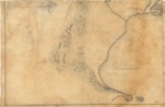
Early map of Puerto Escondida, Baja California, Mexico.
Description
An undated, incomplete chart missing the upper half where there most likely was a population plan and index that corresponded to the alphabetical notations on the map. It is missing any type of cartouche or legend describing the chart. The title was derived from the content of the map. It appears to be a plan of Puerto Escondido and the islet of Cayo Escondido located in the southeastern part of Baja California, Mexico, some 15 miles south of Loreto on the Sea of Cortez. The chart focuses on topography, reflected by the relief represented by contour lines, as opposed to the port itself in terms of depth. Puerto Escondido is well-known as a natural harbor protected from the strong northeast winds.
Source
Archivo General Militar de Madrid, Spain
Format
PDF File
Language
Spanish
Disciplines
Arts and Humanities | Education | Social and Behavioral Sciences
Original Format
Paper
Document Type
Map
Recommended Citation
"17__ - Plano de Punta Escondida y del islote de Cayo Escondido en la parte suroriental de la Baja California" (2017). Pre-1824 Maps. 52.
https://digitalcommons.csumb.edu/hornbeck_spa_1_a/52
