
Files
Download Full Text (163.4 MB)
Subject
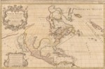
1680 map depicting North America divided into its principal parts, English, Spanish and French.
Description
1680 map depicting North America divided into its principal parts, viz. Arctick lands, New North Wales, N. South Wales, N. Britain, Canada, N. France, N. Scotland, N. England, N. York, N. Jersey, Mary-Land, Virginia, Carolina, Florida, Mexico, the islands of New Found Land, California, the Antilles, in which are distinguished the several countries as they are possessed by the English, Spanish and French.
Source
Library of Congress
Format
PDF File
Language
English
Disciplines
Arts and Humanities | Education | Social and Behavioral Sciences
Original Format
Paper
Document Type
Map
Recommended Citation
"1680 - North America divided into its principall parts where are distinguished the several states which belong to the English, Spanish, and French" (2017). Pre-1824 Maps. 9.
https://digitalcommons.csumb.edu/hornbeck_spa_1_a/9
