
Files
Download Full Text (9.9 MB)
Subject
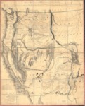
1848 map depicting the Oregon Territory and Upper California based on Frémont’s survey of the Western United States made during his third expedition of 1845-1846.
Description
This 1848 map. based on Frémont’s survey of the Western United States made during his third expedition of 1845-1846, was one of the first to depict the creation of the Territory of Oregon and the establishment of the Mexican-United States boundary that was ratified on July 4, 1848. It provided the first depiction of the California region, expanding contemporary geographic knowledge of the Sierra Nevada and Coast Ranges, and the drainage pattern of the Sacramento and San Joaquin valleys. The map showed the location of the discovery of gold deposits along the American and Plumas rivers and introduced numerous California place names including Kern River, Walker Pass, Owens Lake and the Golden Gate, designating the entrance to the San Francisco Bay. It covered California, Nevada and portions of western Arizona and Utah showing Indian tribal areas and unexplored regions. The map filled in many previously empty spaces and offered a fairly accurate picture of the American West as of 1848.
Source
Library of Congress
Format
JPG File
Language
English
Disciplines
Arts and Humanities | Education | Social and Behavioral Sciences
Original Format
Paper
Document Type
Map
Recommended Citation
"1848 -Map of Oregon and Upper California from the surveys of John Charles Frémont and other authorities" (2017). American Period Maps. 12.
https://digitalcommons.csumb.edu/hornbeck_usa_1/12
