
Files
Download Full Text (17.1 MB)
Subject
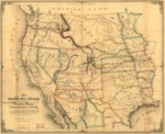
1859 map of the United States west of the Mississippi was based on an 1857 map compiled and drawn from U.S. land and coastal surveys (and other reliable sources) depicting new State and Territorial boundaries and the principal mail and railroad routes.
Description
The 1859 map based on a previously produced Pacific railroad 1957 survey map depicted the United States west of the Mississippi reflecting new State and Territorial boundaries and the principal mail and railroad routes. The U.S. Congress authorized the army topographical service to undertake the engineering surveys and general assessments of five possible railroad routes from: St Paul, Minnesota; Council Bluffs, Iowa; Saint Louis, Missouri; Memphis, Tennessee; and Vicksburg, Mississippi. The map is an example of the promotional maps used to encourage settlement and investment in the West. (Published in Saint Louis, this map emphasized potential routes emanating from that city. The focus on Pike’s Peak highlighted the discovery of gold in Colorado.)
Source
Library of Congress
Format
JPG File
Language
English
Disciplines
Arts and Humanities | Education | Social and Behavioral Sciences
Original Format
Paper
Document Type
Map
Recommended Citation
"1859 - Map of the United States west of the Mississippi showing the routes to Pike's Peak, overland mail route to California and Pacific rail road surveys. To which are added the new state & territorial boundaries, the principal mail & rail road routes with all the arrangements & corrections made by Congress up to the date of its issue." (2017). American Period Maps. 15.
https://digitalcommons.csumb.edu/hornbeck_usa_1/15
