
Files
Download Full Text (71.7 MB)
Subject
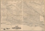
1889 map of Santa Barbara County, California, detailing ranchos, township and section lines, school and supervisorial districts, etc.
Description
An 1889 cadastral map compiled and drawn by Paul Riecker detailing drainage, roads, railroads, land ownership, landowners’ names, ranchos, townships and section lines, school and supervisorial districts, etc. Includes insets of “Map of Santa Barbara,” “Map of Santa Maria,” “Map of Lompoc,” “Map of Los Alamos,” “Map showing Santa Barbara Channel and the Islands of Santa Rosa and Santa Cruz,” and “Table showing area of land grants.”
Source
Library of Congress
Format
JPG File
Language
English
Disciplines
Arts and Humanities | Education | Social and Behavioral Sciences
Original Format
Paper
Document Type
Map
Recommended Citation
"1889 - Map of the County of Santa Barbara, California" (2017). American Period Maps. 18.
https://digitalcommons.csumb.edu/hornbeck_usa_1/18
