
Files
Download Full Text (4.3 MB)
Subject
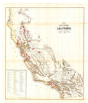
1859 U.S. Surveyor General map of California detailing the location of 196 private land grants that had been surveyed.
Description
September 19, 1859, map of California prepared by the Office of the U.S. Surveyor General. A list of the 196 private grants surveyed is located on the bottom left corner. The private grants are superimposed on the map.
Source
U.S. National Archives
Format
JPG File
Language
English
Disciplines
Arts and Humanities | Education | Law | Physical Sciences and Mathematics
Original Format
Paper
Document Type
Article
Recommended Citation
"1859 - Map of Public Surveys in California" (2016). American Period Maps. 6.
https://digitalcommons.csumb.edu/hornbeck_usa_1/6
Included in
Arts and Humanities Commons, Education Commons, Law Commons, Physical Sciences and Mathematics Commons
