
Maps, Plats, Sketches & Surveys
Files
Download
Download Full Text (203 KB)
Subject
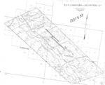
Monterey County Assessor map of San Lorenzo (Randall - Peach Tree) Rancho in Monterey County, California.
Description
Map of the San Lorenzo (Randall - Peach Tree) Rancho subdivided for assessment purposes in Monterey County, California, for the period 1937-1939.
Source
Monterey County Assessor’s Office
Format
TIFF
Language
English
Disciplines
Arts and Humanities | Business | Education | Law | Social and Behavioral Sciences
Original Format
Paper
Document Type
Map
Recommended Citation
"Book No. 245; T19S, R10E; T20S, R10-11E; T21S, R11E; MDM; San Lorenzo (Randall - Peach Tree) Rancho Map – 1937-1939" (2018). Maps, Plats, Sketches & Surveys. 760.
https://digitalcommons.csumb.edu/hornbeck_cgb_14/760
