
Maps, Plats, Sketches & Surveys
Files
Download
Download Full Text (180 KB)
Subject
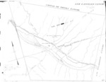
Monterey County Assessor map of Los Laureles (Boronda) in Monterey County, California.
Description
Map of the Los Laureles (Boronda) Rancho subdivided for assessment purposes in Monterey County, California, for the period 1940-1943.
Source
Monterey County Assessor’s Office
Format
TIFF
Language
English
Disciplines
Arts and Humanities | Business | Education | Law | Social and Behavioral Sciences
Original Format
Paper
Document Type
Map
Recommended Citation
"Book No. 187 and 189; T16-17S, R02E; MDM; Los Laureles (Boronda) Rancho Map – 1940-1943" (2018). Maps, Plats, Sketches & Surveys. 989.
https://digitalcommons.csumb.edu/hornbeck_cgb_14/989
