
Files
Download Full Text (8.4 MB)
Subject
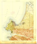
U.S. Geological 1913 topographical survey of the Monterey Quadrangle, Monterey County, California.
Description
A 1913 U.S. Geological topographical survey depicting the Monterey Quadrangle in Monterey County, California covering the region from Point Lobos and the Carmel Valley north to the mouth of the Salinas River.
Source
Office of the United States Geological Surveys
Format
Language
English
Disciplines
Arts and Humanities | Education | Life Sciences | Social and Behavioral Sciences
Original Format
Paper
Document Type
Map
Recommended Citation
"1913 U.S. Geological Survey of the Monterey Quadrangles, Monterey County, California" (2018). Groundwater Basin Maps. 25.
https://digitalcommons.csumb.edu/hornbeck_cgb_4/25
Included in
Arts and Humanities Commons, Education Commons, Life Sciences Commons, Social and Behavioral Sciences Commons
