
Files
Download
Download Full Text (20.7 MB)
Subject
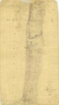
1854 survey reflecting the topography for approximately seven miles along the Monterey Bay from the Salinas River southward.
Description
The 1854 survey depicts the topography for approximately seven miles along the Monterey Bay from the Salinas River southward, including the river, streams, salt and fresh water ponds and roads.
Source
National Oceanic and Atmospheric Administration
Format
JPEG
Language
English
Disciplines
Arts and Humanities | Education | Law | Life Sciences | Social and Behavioral Sciences
Original Format
Paper
Document Type
Map
Recommended Citation
"1854 - Part of the Coast of California from Salinas River Southward, California" (2018). Groundwater Basin Maps. 37.
https://digitalcommons.csumb.edu/hornbeck_cgb_4/37
