
Files
Download Full Text (5.2 MB)
Subject
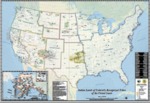
Recognized Indian lands in the United States
Description
Updates to Federally Recognized Tribal Land Boundary Data are subject to update by the BIA on a continuous basis, the data presented is the most current available as of the date of this map. This map and related information were prepared strictly or illustrative and reference purposes only and should not be used, and is not intended for survey, engineering or navigation purposes. The map reflects Federally recognized Tribal Entities (so not have land held in trust or restricted fee status), Alaska Native Villages, Public domain allotments, American Indian Reservations, Oklahoma Tribal statistical areas, trust or restricted fee lands, lakes, swamps and rivers.
Source
U.S. Bureau of Indian Affairs
Format
Language
English
Disciplines
Arts and Humanities | Education | Law | Social and Behavioral Sciences
Original Format
Paper
Document Type
Map
Recommended Citation
"2016 - Bureau of Indian Affairs Map Indian Lands of Federal Recognized Tribes" (2019). Maps. 8.
https://digitalcommons.csumb.edu/hornbeck_ind_2/8
Included in
Arts and Humanities Commons, Education Commons, Law Commons, Social and Behavioral Sciences Commons
