
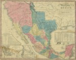
1832 Map of United States of Mexico, Second Edition 1846
Description
This 1846 second edition map depicts the United States of Mexico in 1832; organized and defined by the Acts of the Congress of the Republic; constructed from printed and manuscript documents by H. S. Tanner. Insert table on lower right shows statistical data for the states and territories: Area in Sq. Miles, Miles Square, Population, number of inhabitants to square mile, Capital and it's position Latitude and Longitude) along with population, produce, and terrain. Table of Distances insert on lower left.
This paper has been withdrawn.
