
Files
Download Full Text (150.5 MB)
Subject
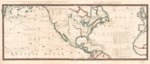
1775 chart depicting North American (including California and New Albion) and the West Indies with the opposite coasts of Europe and Africa.
Description
The 1775 map shows the northeast Pacific Ocean coasts of North America (California and New Albion) and the Aleutian Islands and routes of major exploration between 1542 and 1765. Also shows the north east coasts of North America, West Indies and coasts of Europe and Africa. Relief shown pictorially.
Source
Library of Congress
Format
JPG File
Language
English
Disciplines
Arts and Humanities | Education | Social and Behavioral Sciences
Original Format
Paper
Document Type
Map
Recommended Citation
"1775 - Chart, containing the coasts of California, New Albion, and Russian discoveries to the north; with the peninsula of Kamtschatka, in Asia, opposite thereto; and islands, dispersed over the Paci c Ocean, to the north of the line. North America and the West Indies, with the opposite coasts of Europe and Africa." (2017). Pre-1824 Maps. 11.
https://digitalcommons.csumb.edu/hornbeck_spa_1_a/11
