
Files
Download Full Text (206.1 MB)
Subject
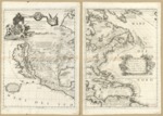
1688 Vincenzo Coronelli map of North American.
Description
1688 Vincenzo Coronelli map has large scene of gods and goddesses of navigation (map, sundial, sun, etc.) at left and large maroon drape above. Great Lakes region is most accurate. California is shown as a massive island with a large mountain ridge down its east side. Longitude 0⁰ goes through Iceland. Mississippi River exits in the Gulf of Mexico some 600 miles to the west of its true location. The Ohio River has been pushed south. In the West, previously unrecorded place names are noted. The Rio Grande is divided into the Rio Norte and the Rio Bravo in the south.
Source
Library of Congress
Format
PDF File
Language
Italian
Disciplines
Arts and Humanities | Education | Social and Behavioral Sciences
Original Format
Paper
Document Type
Map
Recommended Citation
"1688 America Settentrionale colle nuove scoperte n al'anno 1688, divisa nelle sue parti secundo lo stato" (2017). Pre-1824 Maps. 16.
https://digitalcommons.csumb.edu/hornbeck_spa_1_a/16
