
Files
Subject
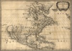
1650 French map of North America with California depicted as an island.
Description
This 1650 map of North America depicts the Great Lakes in a recognizable form naming both Lake Ontario and Lake Superior. The East Coast designation “N[ouvelle] Amsterdam is present day New York and “N[ovelle] Suede” is the Swedish colony, present day Delaware. The area delineated as “Mer Glaciale” refers to the Northwest Passage. The source for the Southwest area are the 1630 reports of Father Alonso Benavides on his travels in New Mexico with many Native tribes describe. The R. del Norte (Rio Grande) is shown mistakenly as flowing from an interior lake and emptying into the Mar Vermeio (Gulf of California). California is shown as a large island.
Source
Library of Congress
Format
PDF File
Language
French
Disciplines
Arts and Humanities | Education | Social and Behavioral Sciences
Original Format
Paper
Document Type
Map
Recommended Citation
"1650 - Amérique septentrional" (2017). Pre-1824 Maps. 17.
https://digitalcommons.csumb.edu/hornbeck_spa_1_a/17
