

Files
Subject
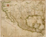
1772 geographic map of most of Spanish North America
Description
The map made principally in 1767 depicts the state of knowledge at that the time that the Spaniards had acquired of Upper-California and the Colorado River, immediately before the commencement of the explorations of the regions by the Franciscan missionaries in 1769 and the Spanish Northwest navigations after 1774. Father José de Alzate y Ramírez drew the original map entitled, Nuevo mapa geográfico de la América septentrional Española, dividida en obispados y provincias, in 1767 (New Geographical Map of Northern Spanish America, divided into Bishoprics and Provinces). This 1772 map was a correction of the previous map made to “bring it into line with new astronomical observations.” Thought to be one of the first maps to show Texas as a geographic region (Provincia de los Texas). The map was drawn from official reports of several Spanish political and military explorers who had inspected the regions.
Source
Archivo del Museo Naval, Órgano De Historia y Cultura Naval; Madrid, Spain
Format
PDF File
Language
Spanish
Disciplines
Arts and Humanities | Education | Social and Behavioral Sciences
Original Format
paper
Document Type
Map
Recommended Citation
"1772 - Plano Geográfico de la mayor parte de la America Septentrional Española" (2017). Pre-1824 Maps. 19.
https://digitalcommons.csumb.edu/hornbeck_spa_1_a/19