
Files
Download Full Text (642 KB)
Subject
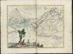
1776 map depicting Northwest coast of North America and Northeast coast of Asia reflecting at Northwest Passage linking the Hudson Bay to the Pacific, the Kingdom of Anian and the mythical Chinese colony, Fou Sang.
Description
Antonio Zatta’s 1776 map of the Northwest and Northeast coasts of North America and Asia, includes the region from the Hudson Bay and Great Lakes westward extending eastward to Siberia and from Cabo San Lucas on the California Baja Peninsula to as far north as Japan and the Artic. In addition to using misunderstood or mythical landmarks such as the Kingdom of Anian and the Chinese colony, Fou Sang, the map depicts the “River of the West” flowing from Hudson Bay to the Pacific Ocean representing the Northwest Passage. Zatta merged virtually every 17th and 18th century myth, fabrication and fact concerning the American West into one map. Much of the factually inaccurate information appears to be based on a legend first appearing in 1706 in an English magazine entitled, “Memoirs of the Curious” that described the purported travels of Spanish Admiral Bartholomew de Fonte. The map’s cartouche depicts an island with tropical animals that include a crocodile, an elephant, a rhinoceros and an ostrich.
Source
Archivo Cartografico y de Estudios Geograficos, Madrid, Spain
Format
JPEG
Language
Italian
Disciplines
Arts and Humanities | Education | Social and Behavioral Sciences
Original Format
Paper
Document Type
Map
Recommended Citation
"1776 - Nuove Scoperte dé Russi al Nord el Mare del Sud sí nell'Asia, che nell'America" (2017). Pre-1824 Maps. 36.
https://digitalcommons.csumb.edu/hornbeck_spa_1_a/36
