

Files
Download Full Text (3.5 MB)
Subject
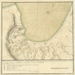
1770 plan by Miguel Constanzó depicting locations where ships might be anchored in the Bay and Port of Monterrey, as well as several landmarks.
Description
A detailed plan by Miguel Constanzó of the Port of Monterrey in which he identifies landmarks and potential locations for anchoring ships, including: Point Pinos, sheltered anchorage (except from the north-northwest winds), the site for the Mission and Presidio de San Carlos, several lagoons and an estuary that was filled by the tide. This is one of at least four Constanzó maps or plans resulting from the Spanish exploration of the coastline of Alta California between 1769 and 1770.
Source
Archivo Cartografico y de Estudios Geograficos, Madrid, Spain
Format
JPEG
Language
Spanish
Disciplines
Arts and Humanities | Education | Social and Behavioral Sciences
Original Format
Paper
Document Type
Map
Recommended Citation
"1770 - Plano del Tondeadero o Surgidero de la Bahia y Puerto de Monterrey - situado por 36 grados y 40 minutos de latitud Norte" (2017). Pre-1824 Maps. 38.
https://digitalcommons.csumb.edu/hornbeck_spa_1_a/38