
-
")
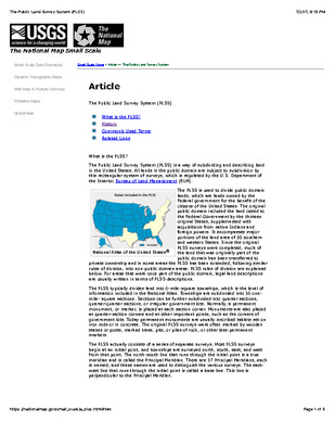
1785 - The Public Land Survey System (PLSS)
Adopted by the United States Congress of Confederation on May 20, 1785, the Land Ordinance was established to provide a means by which the land west of the Appalachian Mountains, north of the Ohio River and East of the Mississippi River could be sold and settled. This article describes the Public Land Survey System (PLSS), a way of subdividing and describing all public domain lands in the United States. Regulated by the U.S. Department of the Interior, the PLSS divides the lands owned by the Federal government into 6-miles square townships and is included in the National Atlas. Townships are divided into 36 one-miles sections that can be further divided into quarter sections, quarter-quarter sections, or even irregular government lots. Each township is identified with a township and range designation with township representing the location north or south of the base line and the range indicating the location east or west of one of 37 named Principal Meridians. The east-west line of each meridian is called the base line
-

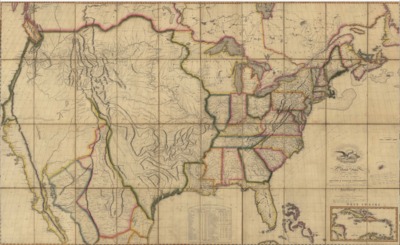
1816 - Map of the United States with the contiguous British and Spanish Possessions
June 6, 1816 map (possibly 6th edition -- handwritten notes on face of map) published by John Melish of Philadelphia. Includes an insert of the West Indies.
-

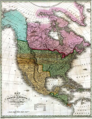
1826 - Map of North America
An 1826 map of North American that includes "all the recent geographical discoveries, drawn by D. H. Vance and published by A. Finley, Philadelphia. Includes a population table exhibiting population of the principal divisions of North America.
-

1847 - Mapa de los Estados Unidos de Méjico, California &c. : segun lo organizado y de nido por las varias actas del congreso de dicha Républica y construido por las mejores autoridades.
This 1847 map depicts the United States of Mexico; Alta California, as well as the souther portion of the United States including Texas, Missouri, Arkansas, Louisiana, Georgia and Florida. Inserts in the map include a distance chart and list, the Chart of the Bay of Vera Curz, map showing the battle grounds of May 8 and 9 1846, Tampico and it's environs and the Plan of Monterey and its environs.
-

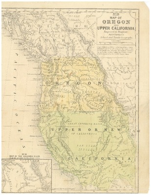
1847 - Map of Oregon and Upper California
No. 15 Map of Oregon and Upper New California engraved to illustrate Mitchell's School and Family Geography, 1847. Also shows a portion of British America to the north of Oregon. Contains No. 16 insert, Map of the Columbia River from the Cascades to the Pacific Ocean in lower left corner.
-

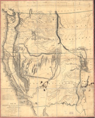
1848 -Map of Oregon and Upper California from the surveys of John Charles Frémont and other authorities
This 1848 map. based on Frémont’s survey of the Western United States made during his third expedition of 1845-1846, was one of the first to depict the creation of the Territory of Oregon and the establishment of the Mexican-United States boundary that was ratified on July 4, 1848. It provided the first depiction of the California region, expanding contemporary geographic knowledge of the Sierra Nevada and Coast Ranges, and the drainage pattern of the Sacramento and San Joaquin valleys. The map showed the location of the discovery of gold deposits along the American and Plumas rivers and introduced numerous California place names including Kern River, Walker Pass, Owens Lake and the Golden Gate, designating the entrance to the San Francisco Bay. It covered California, Nevada and portions of western Arizona and Utah showing Indian tribal areas and unexplored regions. The map filled in many previously empty spaces and offered a fairly accurate picture of the American West as of 1848.
-

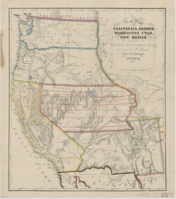
1853 - New map of California, Oregon, Washington, Utah and New Mexico
This 1853 map, based on S. A. Mitchell’s 1846 Map of Texas and California, depicts the United States west of the Rocky Mountains reflecting many important routes of the western migration, including the Spanish Trail from Los Angeles to Santa Fe., Lt. Col. Cooke’s Wagon Trail, and Kearney’s Route along the Rio Gila. (The land south of the Gila River was obtained via treaty from Mexico in the Gadsden Purchase on June 8, 1854.) The map lists numerous mining towns California, including Auburn, Columa [sic], Marysville, Yuba City, Downieville, etc., plus a number of Native American tribal names and references to forts, especially in the southwest and in the Washington and Oregon Territories. Much of the cartography of the Great Basin is conjectural at best, but there are references to Fremont’s Explorations. The map depicts state and county lines.
-

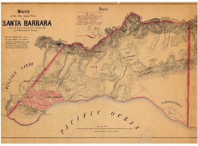
1853 - Sketch of the City Land Claim of Santa Barbara, V. Wackenreuder
An 1853 sketch by V. Wackenreuder, county surveyor, reflecting the City of Santa Barbara land claim containing 8 3/4 square leagues.
-
![1856 - A new map of our country, present and prospective : [United States] : compiled from government surveys and other reliable sources.](https://digitalcommons.csumb.edu/hornbeck_usa_1/1018/thumbnail.jpg "1856 - A new map of our country, present and prospective : [United States] : compiled from government surveys and other reliable sources.")
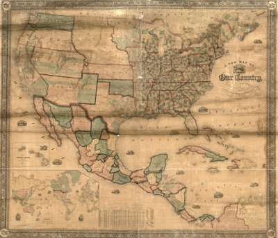
1856 - A new map of our country, present and prospective : [United States] : compiled from government surveys and other reliable sources.
The 1856 map depicts states and territories of the United States; Mexican states, and Central American countries. A large inset contains a world map. A statistical table compares states and territories in terms of area, population, real estate, personal estate, free persons unable to read or write, number of papers, annual circulation, pauperism, persons convict of crimes year ending June 1, 1850, and railroads in the United States as of June 1, 1854. Also, inserts listing the area and population of the Mexican states and the Central American countries.
-

1858 - Map of the Gadsden Purchase - Sonora and portions of New Mexico, Chihuahua & California
An 1858 map by Herman Ehrenberg derived from his private notes and others depicts the Gadsen Purchase and reflects Sonora, portions of New Mexico, Chihauhau and California. It shows a number of alternate railway routes between El Paso and Ft. Yuma, as well as reflecting towns, mountains, gold mines, water courses, forts and Indian villages.
-

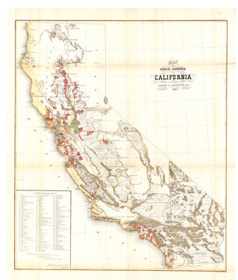
1859 - Map of Public Surveys in California
September 19, 1859, map of California prepared by the Office of the U.S. Surveyor General. A list of the 196 private grants surveyed is located on the bottom left corner. The private grants are superimposed on the map.
-

1859 - Map of the United States west of the Mississippi showing the routes to Pike's Peak, overland mail route to California and Pacific rail road surveys. To which are added the new state & territorial boundaries, the principal mail & rail road routes with all the arrangements & corrections made by Congress up to the date of its issue.
The 1859 map based on a previously produced Pacific railroad 1957 survey map depicted the United States west of the Mississippi reflecting new State and Territorial boundaries and the principal mail and railroad routes. The U.S. Congress authorized the army topographical service to undertake the engineering surveys and general assessments of five possible railroad routes from: St Paul, Minnesota; Council Bluffs, Iowa; Saint Louis, Missouri; Memphis, Tennessee; and Vicksburg, Mississippi. The map is an example of the promotional maps used to encourage settlement and investment in the West. (Published in Saint Louis, this map emphasized potential routes emanating from that city. The focus on Pike’s Peak highlighted the discovery of gold in Colorado.)
-

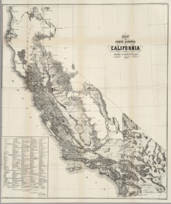
1862 - U.S. Surveyor General Map of California
1862 map of California prepared by the Office of the U.S. Surveyor General. A list of the 430 private grants finally surveyed is located on the bottom left corner. Also lists three Indian Reservations. The private grants are superimposed on the map.
-

1870 Map of the South-Western Portion of the United States and of Sonora and Chihuahua
Map detailing the South-Western Portion of the US and the Mexican states of Sonora and Chihuahua to illustrate the Paper by Dr. W. A. Bell regarding his travels and the route he took during 1867-1868. Contains an insert of Lower California.
-

1874 - Commercial and topographical rail road map & guide of California and Nevada
An 1874 Asher & Adams commercial and topographical railroad map of California and Nevada that depicts drainage, relief by hachures, cities and towns, township and county boundaries, as well as the railroad network with names of lines and distances between the stations.
-

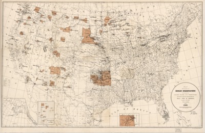
1883 - Map showing Indian reservations with the limits of the United States
An 1883 map compiled under the direction of Hiram Price, Commissioner of Indian Affairs, showing the Indian reservations within the limits of the United States. Insert of Indian Territory in Northeastern Oklahoma.
-

1888 - Map showing the location of the Indian reservations within the limits of the United States and territories
An 1888 map compiled by Bureau of Indian Affairs, showing the Indian reservations within the limits of the United States. Contains inserts of Alaska, Mission Reservation in California, and Indian Territory in Northeastern Oklahoma.
-

1888 – The Unique Map of California
This 1888 map covers the entire state, with insets showing temperature, soil, land area, and scenic images. Annual rainfall in inches is indicated by circled numbers across the map. An inset at the top shows a cross-section of the Sierra Nevada Mountains and the elevation in feet of some of the famous peaks (the heights differ from more accurate present-day measurements). The map charts the main existing railroads (especially Southern Pacific Company’s routes), and emphasizes key products from various regions of California. An inset highlights the size of California, showing that its land mass is larger than that of ten other states combined. Vignettes highlight iconic scenes from the state, including both natural wonders and urban landmarks. Among the natural vistas shown are the Yosemite Valley, Lassen Peak, Mount Whitney, Lake Tahoe, the redwoods, and the Golden Gate.
-

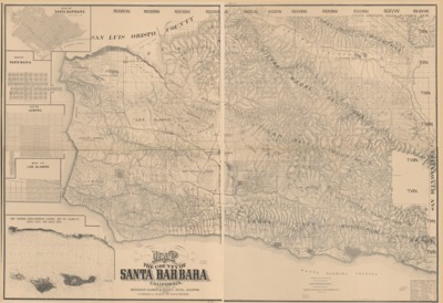
1889 - Map of the County of Santa Barbara, California
An 1889 cadastral map compiled and drawn by Paul Riecker detailing drainage, roads, railroads, land ownership, landowners’ names, ranchos, townships and section lines, school and supervisorial districts, etc. Includes insets of “Map of Santa Barbara,” “Map of Santa Maria,” “Map of Lompoc,” “Map of Los Alamos,” “Map showing Santa Barbara Channel and the Islands of Santa Rosa and Santa Cruz,” and “Table showing area of land grants.”
-

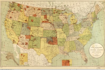
1892 - Map showing Indian reservations within the limits of the United States
An 1892 compiled under the direction of T. J. Morgan, Commissioner of Indian Affairs showing Indian reservations within the limits of the United States, with Inserts of Alaska, the Mission Indian Reservation in California and the Indian Territory in Oklahoma.
-

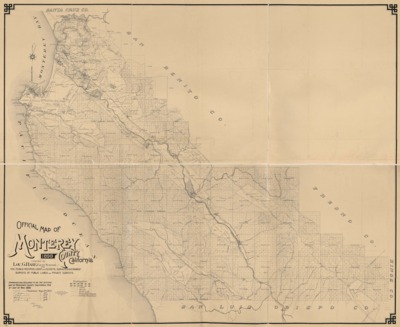
1898 – Official Map of Monterey County
Map prepared in 1898 by Lou G. Hare, County Surveyor, from public records, coast and geodetic surveys, government surveys of public lands and private surveys. Details include land grants, township and range, trails, roads, railroads, irrigation canals and county boundary.
-

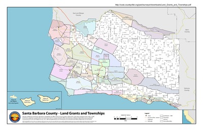
2011 – Santa Barbara County Land Grants and Townships Map
Spanish and Mexican Land Grant information compiled by the Office of the County Surveyor in May of 2011 from plats and patents from 1861 to 1883. Land Grants originally surveyed under instructions from the U.S. Surveyor General's Office, San Francisco, California. Original documents published in pursuance of the Act of Congress of June 14th, 1860 and approved by the Commissioner of the General Land Office, Department of the Interior.
Printing is not supported at the primary Gallery Thumbnail page. Please first navigate to a specific Image before printing.
