

Files
Download Full Text (16.8 MB)
Subject
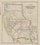
1853 map depicting the United States west of the Rocky Mountains and predating the Gadsden Purchase in 1854 and reflects many important routes of the western migration. Shows state and county lines.
Description
This 1853 map, based on S. A. Mitchell’s 1846 Map of Texas and California, depicts the United States west of the Rocky Mountains reflecting many important routes of the western migration, including the Spanish Trail from Los Angeles to Santa Fe., Lt. Col. Cooke’s Wagon Trail, and Kearney’s Route along the Rio Gila. (The land south of the Gila River was obtained via treaty from Mexico in the Gadsden Purchase on June 8, 1854.) The map lists numerous mining towns California, including Auburn, Columa [sic], Marysville, Yuba City, Downieville, etc., plus a number of Native American tribal names and references to forts, especially in the southwest and in the Washington and Oregon Territories. Much of the cartography of the Great Basin is conjectural at best, but there are references to Fremont’s Explorations. The map depicts state and county lines.
Source
Library of Congress
Format
JPG File
Language
English
Disciplines
Arts and Humanities | Education | Social and Behavioral Sciences
Original Format
Paper
Document Type
Article
Recommended Citation
"1853 - New map of California, Oregon, Washington, Utah and New Mexico" (2017). American Period Maps. 13.
https://digitalcommons.csumb.edu/hornbeck_usa_1/13