
Files
Download
Download Full Text (72.6 MB)
Subject
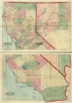
1874 commercial and topographical railroad map and guide to California and Nevada.
Description
An 1874 Asher & Adams commercial and topographical railroad map of California and Nevada that depicts drainage, relief by hachures, cities and towns, township and county boundaries, as well as the railroad network with names of lines and distances between the stations.
Source
Library of Congress
Format
JPG File
Language
English
Disciplines
Arts and Humanities | Education | Social and Behavioral Sciences
Original Format
Paper
Document Type
Map
Recommended Citation
"1874 - Commercial and topographical rail road map & guide of California and Nevada" (2017). American Period Maps. 16.
https://digitalcommons.csumb.edu/hornbeck_usa_1/16
