
-
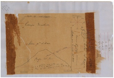
![El Rincón [Yorba], Diseño 384, GLO No. 476, Riverside County, and associated historical documents.](https://digitalcommons.csumb.edu/hornbeck_usa_4_a_rc/1000/thumbnail.jpg "El Rincón [Yorba], Diseño 384, GLO No. 476, Riverside County, and associated historical documents.")
El Rincón [Yorba], Diseño 384, GLO No. 476, Riverside County, and associated historical documents.
Diseños - Hand-drawn Spanish-Mexican map demonstrating the physical boundaries of land granted to Mexican citizens by the Spanish or Mexican.
Work Progress Administration Abstract (WPA Abstract) – A summary document prepared in 1938 under the Work Progress Administration program detailing the history of a rancho beginning with the Spanish-American land through the U.S. patenting process.
-
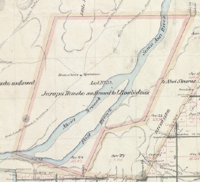
, Diseño 463, GLO No. 482, Riverside County, and associated historical documents.")
Jurupa (Rubidoux), Diseño 463, GLO No. 482, Riverside County, and associated historical documents.
Work Progress Administration Abstract (WPA Abstract) – A summary document prepared in 1938 under the U.S. Work Progress Administration program detailing the history of a rancho beginning with the Spanish-American land through the U.S. patenting process.
Bancroft Notes – Document detailing information and documents regarding a rancho found in the Bancroft Archives.
BLM Land Grant Patent – Hand-written document issued by the U.S. Government providing legal ownership of land previously granted by the Spanish or Mexican government.
BLM Land Patent Detail Sheet – Document using the BLM accession number that provides specific information regarding the patented land of a rancho.
BLM CDI Detail Sheet - Document using the CDI Doc ID that provides specific information concerning the patented land of a rancho.
BLM Survey(s) – Plat(s) prepared by the Office of the U.S. Surveyor General detailing the boundaries of the rancho.
-
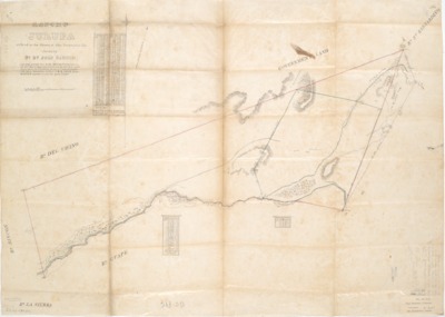
, Diseño 316, GLO No. 483, Riverside County, and associated historical documents.")
Jurupa (Stearns), Diseño 316, GLO No. 483, Riverside County, and associated historical documents.
Bancroft Diseños – Hand-drawn Spanish-Mexican map demonstrating the physical boundaries of land granted to Mexican citizens by the Spanish or Mexican governments used in the U.S. District Court proceedings.
Work Progress Administration Abstract (WPA Abstract) – A summary document prepared in 1938 under the U.S. Work Progress Administration program detailing the history of a rancho beginning with the Spanish-American land through the U.S. patenting process.
Hoffman Table of Land Claims Appendix, Reports on Land Cases, Vol. I, 1862, Ogden Hoffman – Index of land claims, in chronological order by Diseño number, made to the U.S. Land Commission for rancho land previously granted by the Spanish/Mexican governments in California.
Bancroft Plat/Map/Sketch/Diagram – A plat, map or diagram of the patented rancho prepared by the U.S. Surveyor General.
Bancroft Notes – Document detailing information and documents regarding a rancho found in the Bancroft Archives.
BLM Land Grant Patent – Hand-written document issued by the U.S. Government providing legal ownership of land previously granted by the Spanish or Mexican government.
BLM Land Patent Detail Sheet – Document using the BLM accession number that provides specific information regarding the patented land of a rancho.
BLM CDI Detail Sheet - Document using the CDI Doc ID that provides specific information concerning the patented land of a rancho.
BLM Survey(s) – Plat(s) prepared by the Office of the U.S. Surveyor General detailing the boundaries of the rancho.
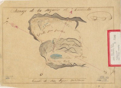
-
, Diseño 346, GLO No. 495, Riverside County, and associated historical documents.")
La Laguna (Stearns), Diseño 346, GLO No. 495, Riverside County, and associated historical documents.
Bancroft Diseños – Hand-drawn Spanish-Mexican map demonstrating the physical boundaries of land granted to Mexican citizens by the Spanish or Mexican governments used in the U.S. District Court proceedings.
Work Progress Administration Abstract (WPA Abstract) – A summary document prepared in 1938 under the U.S. Work Progress Administration program detailing the history of a rancho beginning with the Spanish-American land through the U.S. patenting process.
Bancroft Notes – Document detailing information and documents regarding a rancho found in the Bancroft Archives.
BLM Land Grant Patent – Hand-written document issued by the U.S. Government providing legal ownership of land previously granted by the Spanish or Mexican government.
BLM Land Patent Detail Sheet – Document using the BLM accession number that provides specific information regarding the patented land of a rancho.
BLM CDI Detail Sheet - Document using the CDI Doc ID that provides specific information concerning the patented land of a rancho.
BLM Survey(s) – Plat(s) prepared by the Office of the U.S. Surveyor General detailing the boundaries of the rancho.
-
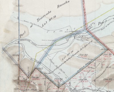
, Diseño 435, GLO 491, Riverside County, and associated historical documents.")
Land in the Valley of Temecula (Apis), Diseño 435, GLO 491, Riverside County, and associated historical documents.
Diseños - Hand-drawn Spanish-Mexican map demonstrating the physical boundaries of land granted to Mexican citizens by the Spanish or Mexican.
Work Progress Administration Abstract (WPA Abstract) – A summary document prepared in 1938 under the U.S. Work Progress Administration program detailing the history of a rancho beginning with the Spanish-American land through the U.S. patenting process.
Bancroft Notes – Document detailing information and documents regarding a rancho found in the Bancroft Archives.
BLM Land Grant Patent – Hand-written document issued by the U.S. Government providing legal ownership of land previously granted by the Spanish or Mexican government.
BLM Land Patent Detail Sheet – Document using the BLM accession number that provides specific information regarding the patented land of a rancho.
BLM CDI Detail Sheet - Document using the CDI Doc ID that provides specific information concerning the patented land of a rancho.
BLM Survey(s) – Plat(s) prepared by the Office of the U.S. Surveyor General detailing the boundaries of the rancho.
-
, Diseño 453, GLO No. 484, Riverside County, and associated historical documents.")
La Sierra (Sepulveda), Diseño 453, GLO No. 484, Riverside County, and associated historical documents.
Diseños - Hand-drawn Spanish-Mexican map demonstrating the physical boundaries of land granted to Mexican citizens by the Spanish or Mexican.
Work Progress Administration Abstract (WPA Abstract) – A summary document prepared in 1938 under the Work Progress Administration program detailing the history of a rancho beginning with the Spanish-American land through the U.S. patenting process.
-
, Diseño 382, GLO No. 485, Riverside County, and associated historical documents.")
La Sierra (Yorba), Diseño 382, GLO No. 485, Riverside County, and associated historical documents.
Diseños - Hand-drawn Spanish-Mexican map demonstrating the physical boundaries of land granted to Mexican citizens by the Spanish or Mexican.
Work Progress Administration Abstract (WPA Abstract) – A summary document prepared in 1938 under the Work Progress Administration program detailing the history of a rancho beginning with the Spanish-American land through the U.S. patenting process.
-

Pauba, Diseño 341, GLO No. 490, Riverside County, and associated historical documents.
Diseños - Hand-drawn Spanish-Mexican map demonstrating the physical boundaries of land granted to Mexican citizens by the Spanish or Mexican.
Work Progress Administration Abstract (WPA Abstract) – A summary document prepared in 1938 under the Work Progress Administration program detailing the history of a rancho beginning with the Spanish-American land through the U.S. patenting process.
-

Potreros of San Juan Capistrano, Diseño 394, GLO No. 494, Riverside County, and associated historical documents.
Diseños - Hand-drawn Spanish-Mexican map demonstrating the physical boundaries of land granted to Mexican citizens by the Spanish or Mexican.
Work Progress Administration Abstract (WPA Abstract) – A summary document prepared in 1938 under the Work Progress Administration program detailing the history of a rancho beginning with the Spanish-American land through the U.S. patenting process.
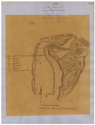
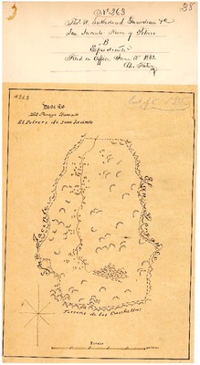
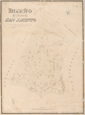
-
, Diseño 263, GLO No. 487, Riverside County, and associated historical documents.")
San Jacinto Nuevo y Potrero, Riverside (formerly San Diego), Diseño 263, GLO No. 487, Riverside County, and associated historical documents.
Diseños - Hand-drawn Spanish-Mexican map demonstrating the physical boundaries of land granted to Mexican citizens by the Spanish or Mexican.
Work Progress Administration Abstract (WPA Abstract) – A summary document prepared in 1938 under the Work Progress Administration program detailing the history of a rancho beginning with the Spanish-American land through the U.S. patenting process.
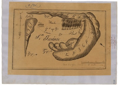
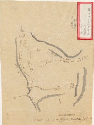
-
, Diseño 115, GLO No. 489, Riverside County, and associated historical documents.")
San Jacinto, Riverside (formerly San Diego), Diseño 115, GLO No. 489, Riverside County, and associated historical documents.
Diseños - Hand-drawn Spanish-Mexican map demonstrating the physical boundaries of land granted to Mexican citizens by the Spanish or Mexican.
Work Progress Administration Abstract (WPA Abstract) – A summary document prepared in 1938 under the Work Progress Administration program detailing the history of a rancho beginning with the Spanish-American land through the U.S. patenting process.
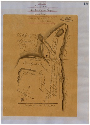
-

San Jacinto y San Gorgonio, Tract between, Diseño 443, GLO No. 488, Riverside County, and associated historical documents.
Diseños - Hand-drawn Spanish-Mexican map demonstrating the physical boundaries of land granted to Mexican citizens by the Spanish or Mexican.
Work Progress Administration Abstract (WPA Abstract) – A summary document prepared in 1938 under the Work Progress Administration program detailing the history of a rancho beginning with the Spanish-American land through the U.S. patenting process.
-
, Diseño 486, GLO No. 493, Riverside County, and associated historical documents.")
Santa Rosa (Morino), Diseño 486, GLO No. 493, Riverside County, and associated historical documents.
Diseños - Hand-drawn Spanish-Mexican map demonstrating the physical boundaries of land granted to Mexican citizens by the Spanish or Mexican.
Work Progress Administration Abstract (WPA Abstract) – A summary document prepared in 1938 under the Work Progress Administration program detailing the history of a rancho beginning with the Spanish-American land through the U.S. patenting process.
-

Sobrante de San Jacinto, Diseño 116, GLO No. 486, Riverside County, and associated historical documents.
Bancroft Diseños – Hand-drawn Spanish-Mexican map demonstrating the physical boundaries of land granted to Mexican citizens by the Spanish or Mexican governments used in the U.S. District Court proceedings.
Work Progress Administration Abstract (WPA Abstract) – A summary document prepared in 1938 under the U.S. Work Progress Administration program detailing the history of a rancho beginning with the Spanish-American land through the U.S. patenting process.
Bancroft Plat/Map/Sketch/Diagram – A plat, map or diagram of the patented rancho prepared by the U.S. Surveyor General.
Bancroft Notes – Document detailing information and documents regarding a rancho found in the Bancroft Archives.
BLM Land Grant Patent – Hand-written document issued by the U.S. Government providing legal ownership of land previously granted by the Spanish or Mexican government.
BLM Land Patent Detail Sheet – Document using the BLM accession number that provides specific information regarding the patented land of a rancho.
BLM CDI Detail Sheet - Document using the CDI Doc ID that provides specific information concerning the patented land of a rancho.
BLM Survey(s) – Plat(s) prepared by the Office of the U.S. Surveyor General detailing the boundaries of the rancho.
-
, Diseño 342, GLO No. 492, Riverside County, and associated historical documents.")
Temécula (Vignes), Diseño 342, GLO No. 492, Riverside County, and associated historical documents.
Diseños - Hand-drawn Spanish-Mexican map demonstrating the physical boundaries of land granted to Mexican citizens by the Spanish or Mexican.
Work Progress Administration Abstract (WPA Abstract) – A summary document prepared in 1938 under the U.S. Work Progress Administration program detailing the history of a rancho beginning with the Spanish-American land through the U.S. patenting process.
Bancroft Notes – Document detailing information and documents regarding a rancho found in the Bancroft Archives.
BLM Land Grant Patent – Hand-written document issued by the U.S. Government providing legal ownership of land previously granted by the Spanish or Mexican government.
BLM Land Patent Detail Sheet – Document using the BLM accession number that provides specific information regarding the patented land of a rancho.
BLM CDI Detail Sheet - Document using the CDI Doc ID that provides specific information concerning the patented land of a rancho.
BLM Survey(s) – Plat(s) prepared by the Office of the U.S. Surveyor General detailing the boundaries of the rancho.
Printing is not supported at the primary Gallery Thumbnail page. Please first navigate to a specific Image before printing.
