
Files
Download Full Text (1.3 MB)
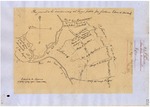
Download National Archives Diseño 228, #2 – Todos Santos y San Antonio, GLO 357 (835 KB)
Download WPA Abstract – Todos Santos y San Antonio, GLO 357 (1.7 MB)
Download Bancroft Notes – Todos Santos y San Antonio, GLO 357 (42 KB)
Download BLM Patent, Dec. 20, 1876 – Todos Santos y San Antonio, GLO 357 (5.1 MB)
Download BLM Land Patent Details – Todos Santos y San Antonio, GLO 357 (440 KB)
Download BLM CDI Details - – Todos Santos y San Antonio, GLO 357 (242 KB)
Download BLM Survey, Apr. 21, 1881 – Todos Santos y San Antonio, GLO 357 (11.6 MB)
Download BLM Survey, Mar. 26, 1889 – Todos Santos y San Antonio, GLO 357 (11.7 MB)
Subject
National Archives Diseños - Spanish/Mexican land grant map.
Work Progress Administration Abstract (WPA Abstract) – Historical details of a Spanish-Mexican land grant that was subsequently patented by the U. S. Government.
Bancroft Notes – Summary of Bancroft Archives information regarding a private land claim.
Bancroft Diseños -- Spanish/Mexican land grant map.
Bancroft Plat/Map/Sketch -- U.S. Surveyor General rancho plat or sketch.
BLM Land Patent – U.S. Government issued document certifying a Private Land Claim.
BLM Land Patent Detail Sheet – BLM Accession number document that provides patent information.
BLM CDI Detail Sheet – CDI Doc ID document that provides patent information.
BLM Survey – Office of the U.S. Surveyor General plat(s) detailing the specific boundaries of land.
Description
National Archives Diseños - Hand-drawn Spanish-Mexican map demonstrating the physical boundaries of land granted to Mexican citizens by the Spanish or Mexican.
Work Progress Administration Abstract (WPA Abstract) – A summary document prepared in 1938 under the U. S. Work Progress Administration program detailing the history of a rancho beginning with the Spanish-American land through the U.S. patenting process.
Bancroft Notes – Document detailing information and documents regarding a rancho found in the Bancroft Archives.
Bancroft Diseños – Hand-drawn Spanish-Mexican map demonstrating the physical boundaries of land granted to Mexican citizens by the Spanish or Mexican governments used in the U.S. District Court proceedings.
Bancroft Plat/Map/Survey – A plat, map or survey of the patented rancho prepared by the U.S. Surveyor General.
BLM Land Patent – Hand-written document issued by the U.S. Government providing legal ownership of land previously granted by the Spanish or Mexican government.
BLM Land Patent Detail Sheet – Document using the BLM accession number that provides specific information regarding the patented land of a rancho.
BLM CDI Detail Sheet - Document using the CDI Doc ID that provides specific information concerning the patented land of a rancho.
BLM Survey(s) – Plat(s) prepared by the Office of the U.S. Surveyor General detailing the boundaries of the rancho.
Source
National Archives Diseño – U.S. National Archives; WPA Abstract - David Hornbeck, Ph.D.; Bancroft documents - Bancroft Archives; BLM documents – U.S. Bureau of Land Management
Format
Language
Spanish; English
Disciplines
Education | Law | Life Sciences | Social and Behavioral Sciences
Original Format
Paper
Document Type
Map
Recommended Citation
"Todos Santos y San Antonio, Diseño 228, GLO No. 357, Santa Barbara County, and associated historical documents." (2018). Santa Barbara County. 52.
https://digitalcommons.csumb.edu/hornbeck_usa_4_a_sabc/52
Included in
Education Commons, Law Commons, Life Sciences Commons, Social and Behavioral Sciences Commons
