

Township and Range Surveys - BLM
Files
Download Full Text (12.7 MB)
Subject
Survey of Monterey County Township and Range prepared by the Office of the Surveyor General
Description
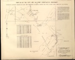
A Apr. 17, 1961, survey or plat reflecting the Township, Range and Sections of T15S, R2&3E, T14S, R1&2E, located in Monterey County, California, USA
Source
Bureau of Land Management, General Land Office Records
Format
PDF File
Language
English
Disciplines
Arts and Humanities | Business | Education | Law | Physical Sciences and Mathematics | Social and Behavioral Sciences
Original Format
Paper
Document Type
Map
Recommended Citation
"T15S, R2&3E, T14S, R1&2E, BLM Plat_315537_1 - Apr. 17, 1961, Portion of Fort Ord Military Reservation Boundary Survey" (2018). Township and Range Surveys - BLM. 146.
https://digitalcommons.csumb.edu/hornbeck_cgb_13/146
Included in
Arts and Humanities Commons, Business Commons, Education Commons, Law Commons, Physical Sciences and Mathematics Commons, Social and Behavioral Sciences Commons