
Files
Download Full Text (13.0 MB)
Subject
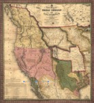
1846 map of Texas (to the Upper Rio Grande in present day New Mexico), Oregon, Upper California, Missouri Territory and a massive Indian Territory (covering much of Kansas and Colorado).
Description
This 1846 map was published just before the War with Mexico, showing the recently annexed former Republic of Texas including its claims into present day New Mexico and Colorado. It also depicted the Oregon Territory, Upper California, Missouri Territory and a massive Indian Territory that covered much of Kansas and Colorado. A table notes the reputed distances of the main points of interest on the route betwee Westport, Missouri and Oregon City. The map was widely used by the flood of American emigrants to the Pacific Northwest.
Source
Library of Congress
Format
JPG File
Language
English
Disciplines
Arts and Humanities | Education | Social and Behavioral Sciences
Original Format
Paper
Document Type
Map
Recommended Citation
"1846 - A New Map of Texas, Oregon and California." (2017). Pre-1846 Maps. 7.
https://digitalcommons.csumb.edu/hornbeck_mex_1/7
