

Files
Download Full Text (14.7 MB)
Subject
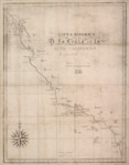
1839 chart of the coast of the Alta California: between parallels of 32 ° and 38 ° north depicting coastal depths, drainage, missions, pueblos, presidios, etc.
Description
This 1839 chart of the coast of the Alta California: between parallels of 32 ° and 38 ° north depicting coastal depths, drainage, missions, pueblos, presidios, etc. It is one of the earliest printed maps devoted specifically to Alta California. It is unusual in that it was one of the first maps printed and published in Hawaii.
Source
Library of Congress
Format
JPEG File
Language
Spanish
Disciplines
Arts and Humanities | Education | Social and Behavioral Sciences
Original Format
Paper
Document Type
Map
Recommended Citation
"1839 - Carta esférica de la costa de la Alta California : comprendida entre los paralelos de 32° y 38° norte." (2017). Pre-1846 Maps. 6.
https://digitalcommons.csumb.edu/hornbeck_mex_1/6