

Files
Download Full Text (966 KB)
Download Expediente No. 25 - Cienega de los Paicines, GLO 268 (8.7 MB)
Download WPA Abstract - Cienega de los Paicines, GLO 268 (1.5 MB)
Download Hornbeck Rancho Detail Sheet - Cienega de los Paicines, GLO 268 (137 KB)
Download Bancroft Notes - Cienega de los Paicines, GLO 268 (58 KB)
Download BLM Patent, Sep. 23, 1869 - Cienega de los Paicines, GLO 268 (766 KB)
Download BLM Land Patent Details - Cienega de los Paicines, GLO 268 (93 KB)
Download BLM CDI Details - Cienega de los Paicines, GLO 268 (78 KB)
Download BLM Survey, May 4, 1860 - Cienega de los Paicines, GLO 268 (12.0 MB)
Download BLM Survey, Oct. 26, 1875 - Cienega de los Paicines, GLO 268 (11.9 MB)
Download BLM Survey, Feb. 28, 1883 - Cienega de los Paicines, GLO 268 (12.3 MB)
Download BLM Survey, May 22, 1884 - Cienega de los Paicines, GLO 268 (12.2 MB)
Download BLM Survey, Oct. 26, 1900 - Cienega de los Paicines, GLO 268 (14.0 MB)
Subject
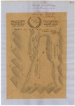
Diseños - Spanish/Mexican land grant map.
Expediente - Spanish/Mexican land grant document.
Work Progress Administration Abstract (WPA Abstract) – Historical details of a Spanish-Mexican land grant that was subsequently patented by the U. S. Government.
Hoffman Notes -- Summary of information on Rancho from Appendix listing Table of Land Claims in the Reports of Land Cases by Ogden Hoffman, Volume I, 1862.
Hoffman Table of Land Claims Appendix, Reports on Land Cases, Vol. I, 1862, Ogden Hoffman -- Index of land claims in California made to the U.S. Land Commission.
Hornbeck Rancho Detail Sheet – History of a California rancho.
Bancroft Notes – Summary of Bancroft Archives information regarding a private land claim.
Bancroft Diseños -- Spanish/Mexican land grant map.
Bancroft Plat/Map/Sketch -- U.S. Surveyor General rancho plat or sketch.
BLM Land Grant Patent – U.S. Government issued document certifying a Private Land Claim.
BLM Land Patent Detail Sheet – BLM Accession number document that provides patent information.
BLM CDI Detail Sheet – CDI Doc ID document that provides patent information.
BLM Survey – Office of the U.S. Surveyor General plat(s) detailing the specific boundaries of land.
Description
Diseños - Hand-drawn Spanish-Mexican map demonstrating the physical boundaries of land granted to Mexican citizens by the Spanish or Mexican.
Expediente – Hand-written Spanish-Mexican land grant document issued to Spanish or Mexican citizens for land located in Alta-California.
Work Progress Administration Abstract (WPA Abstract) – A summary document prepared in 1938 under the U. S. Work Progress Administration program detailing the history of a rancho beginning with the Spanish-American land through the U.S. patenting process.
Hoffman Notes -- Summary of information concerning claims made for the Rancho lands from the Appendix containing the Table of Land Claims in the Reports of Land Cases by Ogden Hoffman, Volume I, 1862.
Hoffman Table of Land Claims Appendix, Reports on Land Cases, Vol. I, 1862, Ogden Hoffman – Index of land claims, in chronological order by Diseño number, made to the U.S. Land Commission for rancho land previously granted by the Spanish/Mexican governments in California.
Hornbeck Rancho Detail Sheet – A summary sheet generated from a land patent database that details the history of a rancho, along with the various state and federal agency record numbers relating to the rancho.
Bancroft Notes – Document detailing information and documents regarding a rancho found in the Bancroft Archives.
Bancroft Diseños – Hand-drawn Spanish-Mexican map demonstrating the physical boundaries of land granted to Mexican citizens by the Spanish or Mexican governments used in the U.S. District Court proceedings.
Bancroft Plat/Map/Survey – A plat, map or survey of the patented rancho prepared by the U.S. Surveyor General.
BLM Land Grant Patent – Hand-written document issued by the U.S. Government providing legal ownership of land previously granted by the Spanish or Mexican government.
BLM Land Patent Detail Sheet – Document using the BLM accession number that provides specific information regarding the patented land of a rancho.
BLM CDI Detail Sheet - Document using the CDI Doc ID that provides specific information concerning the patented land of a rancho.
BLM Survey(s) – Plat(s) prepared by the Office of the U.S. Surveyor General detailing the boundaries of the rancho.
Source
For Diseños – National Archives (or Bancroft Archives); For Expediente – National Archives; For WPA Abstract – David Hornbeck, Ph.D.; For Hornbeck; Rancho Detail Sheet – David Hornbeck, Ph.D.; For Bancroft Notes – Bancroft Archives; For Bancroft Diseños – Bancroft Archives; For BLM Patents – Bureau of Land Management; BLM Land Patent Details – Bureau of Land Management; For BLM CDI Details – Bureau of Land Management; For BLM Surveys – Bureau of Land Management
Format
Language
Spanish; English
Disciplines
Arts and Humanities | Education | Law | Life Sciences | Social and Behavioral Sciences
Original Format
Paper
Document Type
Map
Recommended Citation
"Cienega de los Paicines, Diseño 596, GLO No. 268, San Benito County, and associated historical documents." (2018). San Benito County. 21.
https://digitalcommons.csumb.edu/hornbeck_usa_4_a_sbc/21
Included in
Arts and Humanities Commons, Education Commons, Law Commons, Life Sciences Commons, Social and Behavioral Sciences Commons