

-

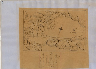
Ausaymas y San Felipe, Diseño 63, GLO No. 233, San Benito County, and associated historical documents.
National Archives Diseños - Hand-drawn Spanish-Mexican map demonstrating the physical boundaries of land granted to Mexican citizens by the Spanish or Mexican.
Expediente – Hand-written Spanish-Mexican land grant document issued to Mexican citizens in Alta California for land in Alta-California.
Work Progress Administration Abstract (WPA Abstract) – A summary document prepared in 1938 under the Work Progress Administration program detailing the history of a rancho beginning with the Spanish-American land through the U.S. patenting process.
Hoffman Notes -- Summary of information concerning claims made for the Rancho lands from the Appendix listing Table of Land Claims in the Reports of Land Cases by Ogden Hoffman, Volume I, 1862.
Hornbeck Rancho Detail Sheet – A summary sheet generated from a land patent database that details the history of a rancho, along with the various state and federal agency record numbers relating to the rancho.
Bancroft Notes – Document detailing information and documents regarding a particular rancho found in the Bancroft Archives.
Bancroft Diseños – Hand-drawn Spanish-Mexican map demonstrating the physical boundaries of land granted to Mexican citizens by the Spanish or Mexican governments used in the U.S. District Court proceedings.
Bancroft Plat – A plat of the patented rancho prepared by the U.S. Surveyor General.
BLM Land Grant Patent – Hand-written document issued by the U.S. Government providing legal ownership of land previously granted by the Spanish or Mexican government.
BLM Land Patent Detail Sheet – Document using the BLM accession number that provides specific information regarding the patented land of a rancho.
BLM CDI Detail Sheet - Document using the CDI Doc ID that provides specific information concerning the patented land of a rancho.
BLM Survey(s) – Plat(s) prepared by the Office of the U.S. Surveyor General detailing the boundaries of the rancho.
-

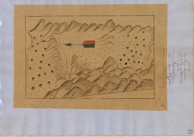
Bolsa de San Felipe, Diseño 65, GLO No. 231, San Benito County, and associated historical documents.
National Archives Diseños - Hand-drawn Spanish-Mexican map demonstrating the physical boundaries of land granted to Mexican citizens by the Spanish or Mexican.
Expediente – Hand-written Spanish-Mexican land grant document issued to Mexican citizens in Alta California for land in Alta-California.
Work Progress Administration Abstract (WPA Abstract) – A summary document prepared in 1938 under the Work Progress Administration program detailing the history of a rancho beginning with the Spanish-American land through the U.S. patenting process.
Hoffman Notes -- Summary of information concerning claims made for the Rancho lands from the Appendix listing Table of Land Claims in the Reports of Land Cases by Ogden Hoffman, Volume I, 1862.
Hornbeck Rancho Detail Sheet – A summary sheet generated from a land patent database that details the history of a rancho, along with the various state and federal agency record numbers relating to the rancho.
Bancroft Notes – Document detailing information and documents regarding a particular rancho found in the Bancroft Archives.
Bancroft Diseños – Hand-drawn Spanish-Mexican map demonstrating the physical boundaries of land granted to Mexican citizens by the Spanish or Mexican governments used in the U.S. District Court proceedings.
Bancroft Plat – A plat of the patented rancho prepared by the U.S. Surveyor General.
BLM Land Grant Patent – Hand-written document issued by the U.S. Government providing legal ownership of land previously granted by the Spanish or Mexican government.
BLM Land Patent Detail Sheet – Document using the BLM accession number that provides specific information regarding the patented land of a rancho.
BLM CDI Detail Sheet - Document using the CDI Doc ID that provides specific information concerning the patented land of a rancho.
BLM Survey(s) – Plat(s) prepared by the Office of the U.S. Surveyor General detailing the boundaries of the rancho.
-

Cienega del Gabilan, Diseño 782, GLO No. 250, San Benito County, and associated historical documents.
National Archives Diseños - Hand-drawn Spanish-Mexican map demonstrating the physical boundaries of land granted to Mexican citizens by the Spanish or Mexican.
Expediente – Hand-written Spanish-Mexican land grant document issued to Mexican citizens in Alta California for land in Alta-California.
Work Progress Administration Abstract (WPA Abstract) – A summary document prepared in 1938 under the Work Progress Administration program detailing the history of a rancho beginning with the Spanish-American land through the U.S. patenting process.
Hoffman Notes -- Summary of information concerning claims made for the Rancho lands from the Appendix listing Table of Land Claims in the Reports of Land Cases by Ogden Hoffman, Volume I, 1862.
Hornbeck Rancho Detail Sheet – A summary sheet generated from a land patent database that details the history of a rancho, along with the various state and federal agency record numbers relating to the rancho.
Bancroft Notes – Document detailing information and documents regarding a particular rancho found in the Bancroft Archives.
Bancroft Diseños – Hand-drawn Spanish-Mexican map demonstrating the physical boundaries of land granted to Mexican citizens by the Spanish or Mexican governments used in the U.S. District Court proceedings.
Bancroft Plat – A plat of the patented rancho prepared by the U.S. Surveyor General.
BLM Land Grant Patent – Hand-written document issued by the U.S. Government providing legal ownership of land previously granted by the Spanish or Mexican government.
BLM Land Patent Detail Sheet – Document using the BLM accession number that provides specific information regarding the patented land of a rancho.
BLM CDI Detail Sheet - Document using the CDI Doc ID that provides specific information concerning the patented land of a rancho.
BLM Survey(s) – Plat(s) prepared by the Office of the U.S. Surveyor General detailing the boundaries of the rancho.
-

Cienega de los Paicines, Diseño 596, GLO No. 268, San Benito County, and associated historical documents.
Diseños - Hand-drawn Spanish-Mexican map demonstrating the physical boundaries of land granted to Mexican citizens by the Spanish or Mexican.
Expediente – Hand-written Spanish-Mexican land grant document issued to Spanish or Mexican citizens for land located in Alta-California.
Work Progress Administration Abstract (WPA Abstract) – A summary document prepared in 1938 under the U. S. Work Progress Administration program detailing the history of a rancho beginning with the Spanish-American land through the U.S. patenting process.
Hoffman Notes -- Summary of information concerning claims made for the Rancho lands from the Appendix containing the Table of Land Claims in the Reports of Land Cases by Ogden Hoffman, Volume I, 1862.
Hoffman Table of Land Claims Appendix, Reports on Land Cases, Vol. I, 1862, Ogden Hoffman – Index of land claims, in chronological order by Diseño number, made to the U.S. Land Commission for rancho land previously granted by the Spanish/Mexican governments in California.
Hornbeck Rancho Detail Sheet – A summary sheet generated from a land patent database that details the history of a rancho, along with the various state and federal agency record numbers relating to the rancho.
Bancroft Notes – Document detailing information and documents regarding a rancho found in the Bancroft Archives.
Bancroft Diseños – Hand-drawn Spanish-Mexican map demonstrating the physical boundaries of land granted to Mexican citizens by the Spanish or Mexican governments used in the U.S. District Court proceedings.
Bancroft Plat/Map/Survey – A plat, map or survey of the patented rancho prepared by the U.S. Surveyor General.
BLM Land Grant Patent – Hand-written document issued by the U.S. Government providing legal ownership of land previously granted by the Spanish or Mexican government.
BLM Land Patent Detail Sheet – Document using the BLM accession number that provides specific information regarding the patented land of a rancho.
BLM CDI Detail Sheet - Document using the CDI Doc ID that provides specific information concerning the patented land of a rancho.
BLM Survey(s) – Plat(s) prepared by the Office of the U.S. Surveyor General detailing the boundaries of the rancho.
-

Las Aromitas y Agua Caliente, Diseño 20, GLO No. 242, San Benito County, and associated historical documents.
National Archives Diseños - Hand-drawn Spanish-Mexican map demonstrating the physical boundaries of land granted to Mexican citizens by the Spanish or Mexican.
Expediente – Hand-written Spanish-Mexican land grant document issued to Mexican citizens in Alta California for land in Alta-California.
Work Progress Administration Abstract (WPA Abstract) – A summary document prepared in 1938 under the Work Progress Administration program detailing the history of a rancho beginning with the Spanish-American land through the U.S. patenting process.
Hoffman Notes -- Summary of information concerning claims made for the Rancho lands from the Appendix listing Table of Land Claims in the Reports of Land Cases by Ogden Hoffman, Volume I, 1862.
Hornbeck Rancho Detail Sheet – A summary sheet generated from a land patent database that details the history of a rancho, along with the various state and federal agency record numbers relating to the rancho.
Bancroft Notes – Document detailing information and documents regarding a particular rancho found in the Bancroft Archives.
Bancroft Diseños – Hand-drawn Spanish-Mexican map demonstrating the physical boundaries of land granted to Mexican citizens by the Spanish or Mexican governments used in the U.S. District Court proceedings.
Bancroft Plat – A plat of the patented rancho prepared by the U.S. Surveyor General.
BLM Land Grant Patent – Hand-written document issued by the U.S. Government providing legal ownership of land previously granted by the Spanish or Mexican government.
BLM Land Patent Detail Sheet – Document using the BLM accession number that provides specific information regarding the patented land of a rancho.
BLM CDI Detail Sheet - Document using the CDI Doc ID that provides specific information concerning the patented land of a rancho.
BLM Survey(s) – Plat(s) prepared by the Office of the U.S. Surveyor General detailing the boundaries of the rancho.
-

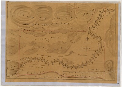
Llano del Tequisquita, Diseño 133, GLO No. 230, San Benito County, and associated historical documents.
National Archives Diseños - Hand-drawn Spanish-Mexican map demonstrating the physical boundaries of land granted to Mexican citizens by the Spanish or Mexican.
Expediente – Hand-written Spanish-Mexican land grant document issued to Mexican citizens in Alta California for land in Alta-California.
Work Progress Administration Abstract (WPA Abstract) – A summary document prepared in 1938 under the Work Progress Administration program detailing the history of a rancho beginning with the Spanish-American land through the U.S. patenting process.
Hoffman Notes -- Summary of information concerning claims made for the Rancho lands from the Appendix listing Table of Land Claims in the Reports of Land Cases by Ogden Hoffman, Volume I, 1862.
Hornbeck Rancho Detail Sheet – A summary sheet generated from a land patent database that details the history of a rancho, along with the various state and federal agency record numbers relating to the rancho.
Bancroft Notes – Document detailing information and documents regarding a particular rancho found in the Bancroft Archives.
Bancroft Diseños – Hand-drawn Spanish-Mexican map demonstrating the physical boundaries of land granted to Mexican citizens by the Spanish or Mexican governments used in the U.S. District Court proceedings.
Bancroft Plat – A plat of the patented rancho prepared by the U.S. Surveyor General.
BLM Land Grant Patent – Hand-written document issued by the U.S. Government providing legal ownership of land previously granted by the Spanish or Mexican government.
BLM Land Patent Detail Sheet – Document using the BLM accession number that provides specific information regarding the patented land of a rancho.
BLM CDI Detail Sheet - Document using the CDI Doc ID that provides specific information concerning the patented land of a rancho.
BLM Survey(s) – Plat(s) prepared by the Office of the U.S. Surveyor General detailing the boundaries of the rancho.
-

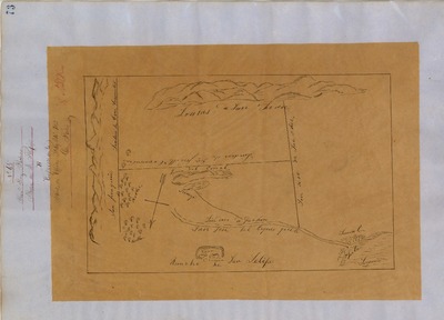
Lomerias Muertas, Diseño 132, GLO No. 239, San Benito County, and associated historical documents.
National Archives Diseños - Hand-drawn Spanish-Mexican map demonstrating the physical boundaries of land granted to Mexican citizens by the Spanish or Mexican.
Expediente – Hand-written Spanish-Mexican land grant document issued to Mexican citizens in Alta California for land in Alta-California.
Work Progress Administration Abstract (WPA Abstract) – A summary document prepared in 1938 under the Work Progress Administration program detailing the history of a rancho beginning with the Spanish-American land through the U.S. patenting process.
Hoffman Notes -- Summary of information concerning claims made for the Rancho lands from the Appendix listing Table of Land Claims in the Reports of Land Cases by Ogden Hoffman, Volume I, 1862.
Hornbeck Rancho Detail Sheet – A summary sheet generated from a land patent database that details the history of a rancho, along with the various state and federal agency record numbers relating to the rancho.
Bancroft Notes – Document detailing information and documents regarding a particular rancho found in the Bancroft Archives.
Bancroft Diseños – Hand-drawn Spanish-Mexican map demonstrating the physical boundaries of land granted to Mexican citizens by the Spanish or Mexican governments used in the U.S. District Court proceedings.
Bancroft Plat – A plat of the patented rancho prepared by the U.S. Surveyor General.
BLM Land Grant Patent – Hand-written document issued by the U.S. Government providing legal ownership of land previously granted by the Spanish or Mexican government.
BLM Land Patent Detail Sheet – Document using the BLM accession number that provides specific information regarding the patented land of a rancho.
BLM CDI Detail Sheet - Document using the CDI Doc ID that provides specific information concerning the patented land of a rancho.
BLM Survey(s) – Plat(s) prepared by the Office of the U.S. Surveyor General detailing the boundaries of the rancho.
-
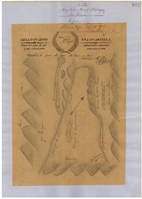
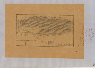
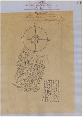
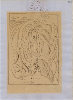
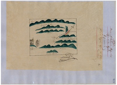
, Diseño 680, GLO No. 246, San Benito County, and associated historical documents.")
Los Carneros (McDougal), Diseño 680, GLO No. 246, San Benito County, and associated historical documents.
National Archives Diseños - Hand-drawn Spanish-Mexican map demonstrating the physical boundaries of land granted to Mexican citizens by the Spanish or Mexican.
Expediente – Hand-written Spanish-Mexican land grant document issued to Mexican citizens in Alta California for land in Alta-California.
Work Progress Administration Abstract (WPA Abstract) – A summary document prepared in 1938 under the Work Progress Administration program detailing the history of a rancho beginning with the Spanish-American land through the U.S. patenting process.
Hoffman Notes -- Summary of information concerning claims made for the Rancho lands from the Appendix listing Table of Land Claims in the Reports of Land Cases by Ogden Hoffman, Volume I, 1862.
Hornbeck Rancho Detail Sheet – A summary sheet generated from a land patent database that details the history of a rancho, along with the various state and federal agency record numbers relating to the rancho.
Bancroft Notes – Document detailing information and documents regarding a particular rancho found in the Bancroft Archives.
Bancroft Diseños – Hand-drawn Spanish-Mexican map demonstrating the physical boundaries of land granted to Mexican citizens by the Spanish or Mexican governments used in the U.S. District Court proceedings.
Bancroft Plat – A plat of the patented rancho prepared by the U.S. Surveyor General.
BLM Land Grant Patent – Hand-written document issued by the U.S. Government providing legal ownership of land previously granted by the Spanish or Mexican government.
BLM Land Patent Detail Sheet – Document using the BLM accession number that provides specific information regarding the patented land of a rancho.
BLM CDI Detail Sheet - Document using the CDI Doc ID that provides specific information concerning the patented land of a rancho.
BLM Survey(s) – Plat(s) prepared by the Office of the U.S. Surveyor General detailing the boundaries of the rancho.
-

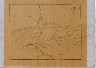
Los Vergeles, Diseño 169, GLO No. 249, San Benito County, and associated historical documents.
National Archives Diseños - Hand-drawn Spanish-Mexican map demonstrating the physical boundaries of land granted to Mexican citizens by the Spanish or Mexican.
Expediente – Hand-written Spanish-Mexican land grant document issued to Mexican citizens in Alta California for land in Alta-California.
Work Progress Administration Abstract (WPA Abstract) – A summary document prepared in 1938 under the Work Progress Administration program detailing the history of a rancho beginning with the Spanish-American land through the U.S. patenting process.
Hoffman Notes -- Summary of information concerning claims made for the Rancho lands from the Appendix listing Table of Land Claims in the Reports of Land Cases by Ogden Hoffman, Volume I, 1862.
Hornbeck Rancho Detail Sheet – A summary sheet generated from a land patent database that details the history of a rancho, along with the various state and federal agency record numbers relating to the rancho.
Bancroft Notes – Document detailing information and documents regarding a particular rancho found in the Bancroft Archives.
Bancroft Diseños – Hand-drawn Spanish-Mexican map demonstrating the physical boundaries of land granted to Mexican citizens by the Spanish or Mexican governments used in the U.S. District Court proceedings.
Bancroft Plat – A plat of the patented rancho prepared by the U.S. Surveyor General.
BLM Land Grant Patent – Hand-written document issued by the U.S. Government providing legal ownership of land previously granted by the Spanish or Mexican government.
BLM Land Patent Detail Sheet – Document using the BLM accession number that provides specific information regarding the patented land of a rancho.
BLM CDI Detail Sheet - Document using the CDI Doc ID that provides specific information concerning the patented land of a rancho.
BLM Survey(s) – Plat(s) prepared by the Office of the U.S. Surveyor General detailing the boundaries of the rancho.
-

Mission San Juan Bautista, Diseño 609, GLO No. 240, San Benito County, and associated historical documents.
National Archives Diseños - Hand-drawn Spanish-Mexican map demonstrating the physical boundaries of land granted to Mexican citizens by the Spanish or Mexican.
Expediente – Hand-written Spanish-Mexican land grant document issued to Mexican citizens in Alta California for land in Alta-California.
Work Progress Administration Abstract (WPA Abstract) – A summary document prepared in 1938 under the Work Progress Administration program detailing the history of a rancho beginning with the Spanish-American land through the U.S. patenting process.
Hoffman Notes -- Summary of information concerning claims made for the Rancho lands from the Appendix listing Table of Land Claims in the Reports of Land Cases by Ogden Hoffman, Volume I, 1862.
Hornbeck Rancho Detail Sheet – A summary sheet generated from a land patent database that details the history of a rancho, along with the various state and federal agency record numbers relating to the rancho.
Bancroft Notes – Document detailing information and documents regarding a particular rancho found in the Bancroft Archives.
Bancroft Diseños – Hand-drawn Spanish-Mexican map demonstrating the physical boundaries of land granted to Mexican citizens by the Spanish or Mexican governments used in the U.S. District Court proceedings.
Bancroft Plat – A plat of the patented rancho prepared by the U.S. Surveyor General.
BLM Land Grant Patent – Hand-written document issued by the U.S. Government providing legal ownership of land previously granted by the Spanish or Mexican government.
BLM Land Patent Detail Sheet – Document using the BLM accession number that provides specific information regarding the patented land of a rancho.
BLM CDI Detail Sheet - Document using the CDI Doc ID that provides specific information concerning the patented land of a rancho.
BLM Survey(s) – Plat(s) prepared by the Office of the U.S. Surveyor General detailing the boundaries of the rancho.
-

Real de los Aguilas, Diseño 628, No. 236, San Benito County, and associated historical documents.
National Archives Diseños - Hand-drawn Spanish-Mexican map demonstrating the physical boundaries of land granted to Mexican citizens by the Spanish or Mexican.
Expediente – Hand-written Spanish-Mexican land grant document issued to Mexican citizens in Alta California for land in Alta-California.
Work Progress Administration Abstract (WPA Abstract) – A summary document prepared in 1938 under the Work Progress Administration program detailing the history of a rancho beginning with the Spanish-American land through the U.S. patenting process.
Hoffman Notes -- Summary of information concerning claims made for the Rancho lands from the Appendix listing Table of Land Claims in the Reports of Land Cases by Ogden Hoffman, Volume I, 1862.
Hornbeck Rancho Detail Sheet – A summary sheet generated from a land patent database that details the history of a rancho, along with the various state and federal agency record numbers relating to the rancho.
Bancroft Notes – Document detailing information and documents regarding a particular rancho found in the Bancroft Archives.
Bancroft Diseños – Hand-drawn Spanish-Mexican map demonstrating the physical boundaries of land granted to Mexican citizens by the Spanish or Mexican governments used in the U.S. District Court proceedings.
Bancroft Plat – A plat of the patented rancho prepared by the U.S. Surveyor General.
BLM Land Grant Patent – Hand-written document issued by the U.S. Government providing legal ownership of land previously granted by the Spanish or Mexican government.
BLM Land Patent Detail Sheet – Document using the BLM accession number that provides specific information regarding the patented land of a rancho.
BLM CDI Detail Sheet - Document using the CDI Doc ID that provides specific information concerning the patented land of a rancho.
BLM Survey(s) – Plat(s) prepared by the Office of the U.S. Surveyor General detailing the boundaries of the rancho.
-

San Benito, Diseño 526, GLO No. 304, San Benito County, and associated historical documents.
National Archives Diseños - Hand-drawn Spanish-Mexican map demonstrating the physical boundaries of land granted to Mexican citizens by the Spanish or Mexican.
Expediente – Hand-written Spanish-Mexican land grant document issued to Mexican citizens in Alta California for land in Alta-California.
Work Progress Administration Abstract (WPA Abstract) – A summary document prepared in 1938 under the Work Progress Administration program detailing the history of a rancho beginning with the Spanish-American land through the U.S. patenting process.
Hoffman Notes -- Summary of information concerning claims made for the Rancho lands from the Appendix listing Table of Land Claims in the Reports of Land Cases by Ogden Hoffman, Volume I, 1862.
Hornbeck Rancho Detail Sheet – A summary sheet generated from a land patent database that details the history of a rancho, along with the various state and federal agency record numbers relating to the rancho.
Bancroft Notes – Document detailing information and documents regarding a particular rancho found in the Bancroft Archives.
Bancroft Diseños – Hand-drawn Spanish-Mexican map demonstrating the physical boundaries of land granted to Mexican citizens by the Spanish or Mexican governments used in the U.S. District Court proceedings.
Bancroft Plat – A plat of the patented rancho prepared by the U.S. Surveyor General.
BLM Land Grant Patent – Hand-written document issued by the U.S. Government providing legal ownership of land previously granted by the Spanish or Mexican government.
BLM Land Patent Detail Sheet – Document using the BLM accession number that provides specific information regarding the patented land of a rancho.
BLM CDI Detail Sheet - Document using the CDI Doc ID that provides specific information concerning the patented land of a rancho.
BLM Survey(s) – Plat(s) prepared by the Office of the U.S. Surveyor General detailing the boundaries of the rancho.
-
![San Joaquin [Cervantes], Diseño 56, GLO No. 232, San Benito County, and associated historical documents for Rancho](https://digitalcommons.csumb.edu/hornbeck_usa_4_a_sbc/1017/thumbnail.jpg "San Joaquin [Cervantes], Diseño 56, GLO No. 232, San Benito County, and associated historical documents for Rancho")
San Joaquin [Cervantes], Diseño 56, GLO No. 232, San Benito County, and associated historical documents for Rancho
National Archives Diseños - Hand-drawn Spanish-Mexican map demonstrating the physical boundaries of land granted to Mexican citizens by the Spanish or Mexican.
Expediente – Hand-written Spanish-Mexican land grant document issued to Mexican citizens in Alta California for land in Alta-California.
Work Progress Administration Abstract (WPA Abstract) – A summary document prepared in 1938 under the Work Progress Administration program detailing the history of a rancho beginning with the Spanish-American land through the U.S. patenting process.
Hoffman Notes -- Summary of information concerning claims made for the Rancho lands from the Appendix listing Table of Land Claims in the Reports of Land Cases by Ogden Hoffman, Volume I, 1862.
Hornbeck Rancho Detail Sheet – A summary sheet generated from a land patent database that details the history of a rancho, along with the various state and federal agency record numbers relating to the rancho.
Bancroft Notes – Document detailing information and documents regarding a particular rancho found in the Bancroft Archives.
Bancroft Diseños – Hand-drawn Spanish-Mexican map demonstrating the physical boundaries of land granted to Mexican citizens by the Spanish or Mexican governments used in the U.S. District Court proceedings.
Bancroft Plat – A plat of the patented rancho prepared by the U.S. Surveyor General.
BLM Land Grant Patent – Hand-written document issued by the U.S. Government providing legal ownership of land previously granted by the Spanish or Mexican government.
BLM Land Patent Detail Sheet – Document using the BLM accession number that provides specific information regarding the patented land of a rancho.
BLM CDI Detail Sheet - Document using the CDI Doc ID that provides specific information concerning the patented land of a rancho.
BLM Survey(s) – Plat(s) prepared by the Office of the U.S. Surveyor General detailing the boundaries of the rancho.
-
![San Juan Bautista, Tract near [Breen], Diseño 560, GLO No. 248, San Benito County, and associated historical documents for Rancho .](https://digitalcommons.csumb.edu/hornbeck_usa_4_a_sbc/1018/thumbnail.jpg "San Juan Bautista, Tract near [Breen], Diseño 560, GLO No. 248, San Benito County, and associated historical documents for Rancho .")
San Juan Bautista, Tract near [Breen], Diseño 560, GLO No. 248, San Benito County, and associated historical documents for Rancho .
National Archives Diseños - Hand-drawn Spanish-Mexican map demonstrating the physical boundaries of land granted to Mexican citizens by the Spanish or Mexican.
Expediente – Hand-written Spanish-Mexican land grant document issued to Mexican citizens in Alta California for land in Alta-California.
Work Progress Administration Abstract (WPA Abstract) – A summary document prepared in 1938 under the Work Progress Administration program detailing the history of a rancho beginning with the Spanish-American land through the U.S. patenting process.
Hoffman Notes -- Summary of information concerning claims made for the Rancho lands from the Appendix listing Table of Land Claims in the Reports of Land Cases by Ogden Hoffman, Volume I, 1862.
Hornbeck Rancho Detail Sheet – A summary sheet generated from a land patent database that details the history of a rancho, along with the various state and federal agency record numbers relating to the rancho.
Bancroft Notes – Document detailing information and documents regarding a particular rancho found in the Bancroft Archives.
Bancroft Diseños – Hand-drawn Spanish-Mexican map demonstrating the physical boundaries of land granted to Mexican citizens by the Spanish or Mexican governments used in the U.S. District Court proceedings.
Bancroft Plat – A plat of the patented rancho prepared by the U.S. Surveyor General.
BLM Land Grant Patent – Hand-written document issued by the U.S. Government providing legal ownership of land previously granted by the Spanish or Mexican government.
BLM Land Patent Detail Sheet – Document using the BLM accession number that provides specific information regarding the patented land of a rancho.
BLM CDI Detail Sheet - Document using the CDI Doc ID that provides specific information concerning the patented land of a rancho.
BLM Survey(s) – Plat(s) prepared by the Office of the U.S. Surveyor General detailing the boundaries of the rancho.
-
![San Juan Bautista, Tract near [Castro], Diseño 607, GLO No. 247-B, San Benito County, and associated historical documents for Rancho.](https://digitalcommons.csumb.edu/hornbeck_usa_4_a_sbc/1015/thumbnail.jpg "San Juan Bautista, Tract near [Castro], Diseño 607, GLO No. 247-B, San Benito County, and associated historical documents for Rancho.")
San Juan Bautista, Tract near [Castro], Diseño 607, GLO No. 247-B, San Benito County, and associated historical documents for Rancho.
National Archives Diseños - Hand-drawn Spanish-Mexican map demonstrating the physical boundaries of land granted to Mexican citizens by the Spanish or Mexican.
Expediente – Hand-written Spanish-Mexican land grant document issued to Mexican citizens in Alta California for land in Alta-California.
Work Progress Administration Abstract (WPA Abstract) – A summary document prepared in 1938 under the Work Progress Administration program detailing the history of a rancho beginning with the Spanish-American land through the U.S. patenting process.
Hoffman Notes -- Summary of information concerning claims made for the Rancho lands from the Appendix listing Table of Land Claims in the Reports of Land Cases by Ogden Hoffman, Volume I, 1862.
Hornbeck Rancho Detail Sheet – A summary sheet generated from a land patent database that details the history of a rancho, along with the various state and federal agency record numbers relating to the rancho.
Bancroft Notes – Document detailing information and documents regarding a particular rancho found in the Bancroft Archives.
Bancroft Diseños – Hand-drawn Spanish-Mexican map demonstrating the physical boundaries of land granted to Mexican citizens by the Spanish or Mexican governments used in the U.S. District Court proceedings.
Bancroft Plat – A plat of the patented rancho prepared by the U.S. Surveyor General.
BLM Land Grant Patent – Hand-written document issued by the U.S. Government providing legal ownership of land previously granted by the Spanish or Mexican government.
BLM Land Patent Detail Sheet – Document using the BLM accession number that provides specific information regarding the patented land of a rancho.
BLM CDI Detail Sheet - Document using the CDI Doc ID that provides specific information concerning the patented land of a rancho.
BLM Survey(s) – Plat(s) prepared by the Office of the U.S. Surveyor General detailing the boundaries of the rancho.
-
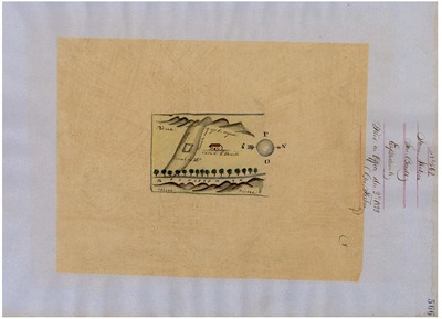
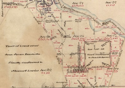
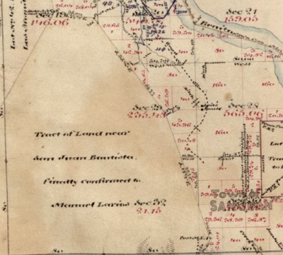
![San Juan Bautista, Tract near [Larios], Diseño 297, GLO No. 247-A, San Benito County, and associated historical documents for Rancho .](https://digitalcommons.csumb.edu/hornbeck_usa_4_a_sbc/1016/thumbnail.jpg "San Juan Bautista, Tract near [Larios], Diseño 297, GLO No. 247-A, San Benito County, and associated historical documents for Rancho .")
San Juan Bautista, Tract near [Larios], Diseño 297, GLO No. 247-A, San Benito County, and associated historical documents for Rancho .
National Archives Diseños - Hand-drawn Spanish-Mexican map demonstrating the physical boundaries of land granted to Mexican citizens by the Spanish or Mexican.
Expediente – Hand-written Spanish-Mexican land grant document issued to Mexican citizens in Alta California for land in Alta-California.
Work Progress Administration Abstract (WPA Abstract) – A summary document prepared in 1938 under the Work Progress Administration program detailing the history of a rancho beginning with the Spanish-American land through the U.S. patenting process.
Hoffman Notes -- Summary of information concerning claims made for the Rancho lands from the Appendix listing Table of Land Claims in the Reports of Land Cases by Ogden Hoffman, Volume I, 1862.
Hornbeck Rancho Detail Sheet – A summary sheet generated from a land patent database that details the history of a rancho, along with the various state and federal agency record numbers relating to the rancho.
Bancroft Notes – Document detailing information and documents regarding a particular rancho found in the Bancroft Archives.
Bancroft Diseños – Hand-drawn Spanish-Mexican map demonstrating the physical boundaries of land granted to Mexican citizens by the Spanish or Mexican governments used in the U.S. District Court proceedings.
Bancroft Plat – A plat of the patented rancho prepared by the U.S. Surveyor General.
BLM Land Grant Patent – Hand-written document issued by the U.S. Government providing legal ownership of land previously granted by the Spanish or Mexican government.
BLM Land Patent Detail Sheet – Document using the BLM accession number that provides specific information regarding the patented land of a rancho.
BLM CDI Detail Sheet - Document using the CDI Doc ID that provides specific information concerning the patented land of a rancho.
BLM Survey(s) – Plat(s) prepared by the Office of the U.S. Surveyor General detailing the boundaries of the rancho.
-

San Justo, Diseño 47, GLO No. 238, San Benito County, and associated historical documents.
National Archives Diseños - Hand-drawn Spanish-Mexican map demonstrating the physical boundaries of land granted to Mexican citizens by the Spanish or Mexican.
Expediente – Hand-written Spanish-Mexican land grant document issued to Mexican citizens in Alta California for land in Alta-California.
Work Progress Administration Abstract (WPA Abstract) – A summary document prepared in 1938 under the Work Progress Administration program detailing the history of a rancho beginning with the Spanish-American land through the U.S. patenting process.
Hoffman Notes -- Summary of information concerning claims made for the Rancho lands from the Appendix listing Table of Land Claims in the Reports of Land Cases by Ogden Hoffman, Volume I, 1862.
Hornbeck Rancho Detail Sheet – A summary sheet generated from a land patent database that details the history of a rancho, along with the various state and federal agency record numbers relating to the rancho.
Bancroft Notes – Document detailing information and documents regarding a particular rancho found in the Bancroft Archives.
Bancroft Diseños – Hand-drawn Spanish-Mexican map demonstrating the physical boundaries of land granted to Mexican citizens by the Spanish or Mexican governments used in the U.S. District Court proceedings.
Bancroft Plat – A plat of the patented rancho prepared by the U.S. Surveyor General.
BLM Land Grant Patent – Hand-written document issued by the U.S. Government providing legal ownership of land previously granted by the Spanish or Mexican government.
BLM Land Patent Detail Sheet – Document using the BLM accession number that provides specific information regarding the patented land of a rancho.
BLM CDI Detail Sheet - Document using the CDI Doc ID that provides specific information concerning the patented land of a rancho.
BLM Survey(s) – Plat(s) prepared by the Office of the U.S. Surveyor General detailing the boundaries of the rancho.
-
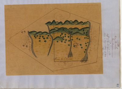
![San Lorenzo [Sanchez], Diseño 674, GLO No. 300, San Benito County, and associated historical documents.](https://digitalcommons.csumb.edu/hornbeck_usa_4_a_sbc/1013/thumbnail.jpg "San Lorenzo [Sanchez], Diseño 674, GLO No. 300, San Benito County, and associated historical documents.")
San Lorenzo [Sanchez], Diseño 674, GLO No. 300, San Benito County, and associated historical documents.
National Archives Diseños - Hand-drawn Spanish-Mexican map demonstrating the physical boundaries of land granted to Mexican citizens by the Spanish or Mexican.
Expediente – Hand-written Spanish-Mexican land grant document issued to Mexican citizens in Alta California for land in Alta-California.
Work Progress Administration Abstract (WPA Abstract) – A summary document prepared in 1938 under the Work Progress Administration program detailing the history of a rancho beginning with the Spanish-American land through the U.S. patenting process.
Hoffman Notes -- Summary of information concerning claims made for the Rancho lands from the Appendix listing Table of Land Claims in the Reports of Land Cases by Ogden Hoffman, Volume I, 1862.
Hornbeck Rancho Detail Sheet – A summary sheet generated from a land patent database that details the history of a rancho, along with the various state and federal agency record numbers relating to the rancho.
Bancroft Notes – Document detailing information and documents regarding a particular rancho found in the Bancroft Archives.
Bancroft Diseños – Hand-drawn Spanish-Mexican map demonstrating the physical boundaries of land granted to Mexican citizens by the Spanish or Mexican governments used in the U.S. District Court proceedings.
Bancroft Plat – A plat of the patented rancho prepared by the U.S. Surveyor General.
BLM Land Grant Patent – Hand-written document issued by the U.S. Government providing legal ownership of land previously granted by the Spanish or Mexican government.
BLM Land Patent Detail Sheet – Document using the BLM accession number that provides specific information regarding the patented land of a rancho.
BLM CDI Detail Sheet - Document using the CDI Doc ID that provides specific information concerning the patented land of a rancho.
BLM Survey(s) – Plat(s) prepared by the Office of the U.S. Surveyor General detailing the boundaries of the rancho.
-

Santa Ana y Quien, Diseños 22 and 55, GLO No. 237, San Benito County, and associated historical documents.
National Archives Diseños - Hand-drawn Spanish-Mexican map demonstrating the physical boundaries of land granted to Mexican citizens by the Spanish or Mexican.
Expediente – Hand-written Spanish-Mexican land grant document issued to Mexican citizens in Alta California for land in Alta-California.
Work Progress Administration Abstract (WPA Abstract) – A summary document prepared in 1938 under the Work Progress Administration program detailing the history of a rancho beginning with the Spanish-American land through the U.S. patenting process.
Hoffman Notes -- Summary of information concerning claims made for the Rancho lands from the Appendix listing Table of Land Claims in the Reports of Land Cases by Ogden Hoffman, Volume I, 1862.
Hornbeck Rancho Detail Sheet – A summary sheet generated from a land patent database that details the history of a rancho, along with the various state and federal agency record numbers relating to the rancho.
Bancroft Notes – Document detailing information and documents regarding a particular rancho found in the Bancroft Archives.
Bancroft Diseños – Hand-drawn Spanish-Mexican map demonstrating the physical boundaries of land granted to Mexican citizens by the Spanish or Mexican governments used in the U.S. District Court proceedings.
Bancroft Plat – A plat of the patented rancho prepared by the U.S. Surveyor General.
BLM Land Grant Patent – Hand-written document issued by the U.S. Government providing legal ownership of land previously granted by the Spanish or Mexican government.
BLM Land Patent Detail Sheet – Document using the BLM accession number that provides specific information regarding the patented land of a rancho.
BLM CDI Detail Sheet - Document using the CDI Doc ID that provides specific information concerning the patented land of a rancho.
BLM Survey(s) – Plat(s) prepared by the Office of the U.S. Surveyor General detailing the boundaries of the rancho.
Printing is not supported at the primary Gallery Thumbnail page. Please first navigate to a specific Image before printing.