

Historical and Contemporary Comparison Maps
Files
Download Full Text (28.7 MB)
Subject
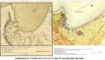
1770 and 1913 maps of the Monterey Bay, California, region.
Description
A comparison of the Monterey Bay area depicted on a 1770 Spanish map prepared by cartographer Miguel Constanzó depicting the Port of Monterrey in which he identified landmarks and potential locations for anchoring ships, including Point Pinos, sheltered anchorage (except from the north-northwest winds), the site for the Mission and Presidio de San Carlos, several lagoons and an estuary that were filled by the tide with a 1913 map of the Monterey Bay area prepared by the U.S.G.S.
Source
Stetson Engineers Inc.
Format
Language
Spanish; English
Disciplines
Arts and Humanities | Business | Education | Law | Life Sciences | Social and Behavioral Sciences
Original Format
Paper and Digital
Document Type
Map
Recommended Citation
"Comparison of 1770 Map with 1913 U.S.G.S. Map of the Monterey Bay Area" (2018). Historical and Contemporary Comparison Maps. 3.
https://digitalcommons.csumb.edu/hornbeck_cgb_12/3
Included in
Arts and Humanities Commons, Business Commons, Education Commons, Law Commons, Life Sciences Commons, Social and Behavioral Sciences Commons