

Maps, Plats, Sketches & Surveys
Files
Download
Download Full Text (327 KB)
Subject
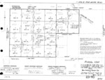
Assessor map in Township 23S, Range 09E and 10E, in Monterey County, California.
Description
Assessor Parcel Map Dividing Section 36 (R9E) and Northwest 1/4 of Section 31 (R10E), San Antonio Ranch Co. in Township 23S, Range 09E and 10E, Monterey County, California.
Source
Monterey County Assessor's Office
Format
TIFF
Language
English
Disciplines
Arts and Humanities | Business | Education | Law | Social and Behavioral Sciences
Original Format
Paper
Document Type
Map
Recommended Citation
"Book No. 423; Township 23S, Range 09E and 10E, Assessor Parcel Map Dividing Section 36 (R9E) and Northwest 1/4 of Section 31 (R10E), San Antonio Ranch Co. - February 1975" (2018). Maps, Plats, Sketches & Surveys. 596.
https://digitalcommons.csumb.edu/hornbeck_cgb_14/596