

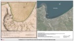
Comparison of 1770 Map with 2016 Satellite Imagery of the Monterey Bay Area
Description
A [draft] comparison of the Monterey Bay area in 1770 as depicted on a Spanish map prepared by cartographer Miguel Constanzó of the Port of Monterrey in which he identified landmarks and potential locations for anchoring ships, including Point Pinos, sheltered anchorage (except from the north-northwest winds), the site for the Mission and Presidio de San Carlos, several lagoons and an estuary that were filled by the tide with the 2016 satellite imagery of the Monterey Bay.
This paper has been withdrawn.